If you have been following this blog, you know that we are always looking for long distance, multi-week hikes in high mountains in remote undiscovered areas.
A series of fortunate events brought us to Kyrgyzstan to help as volunteers in a guesthouse in the small city of Karakol, the gateway to the Tien Shan mountains on the border of Kyrgyzstan, Kazakhstan, and China.
We were very pleasantly surprised to discover that Kyrgyzstan is an extremely welcoming, safe and affordable country, and that the unspoiled Tien Shan mountains offer nearly endless hiking and trekking possibilities without the crowds and limitations of more well-known trekking areas.
There are several popular and very crowded treks close to the town of Karakol itself, ranging from day hikes to six day treks that you can easily do by yourself. We did a couple of these as acclimatization hikes, and I will write a separate blog post about them.
This blog post, however, is about a 13 day trek much deeper into the Tien Shan mountains, where the real wilderness, remoteness, and solitude is found.
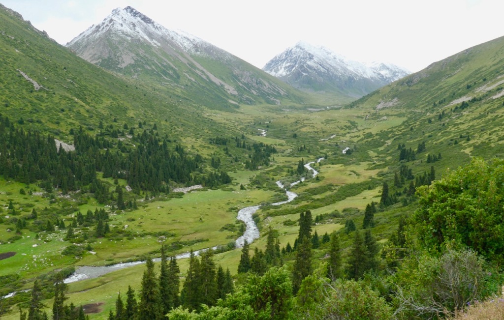
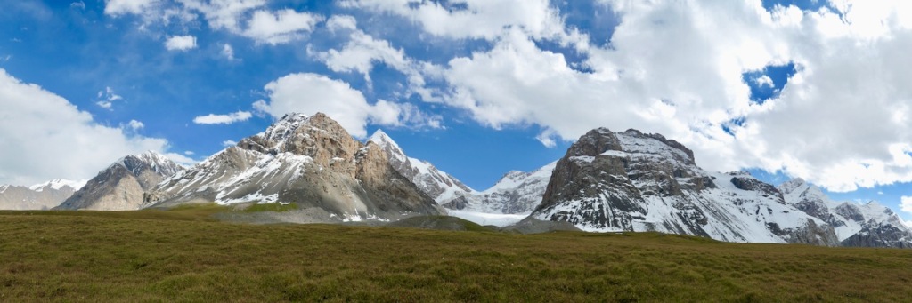
On this trek, there are sections with rolling green hills, where the valleys are filled with herds of sheep and yaks, and where you occasionally run into a yurt. And there are sections with long ranges of high rugged mountains separated by deep river gorges and glacial valleys. Here you cross enormous glaciers, and climb up to 4,000m high snow-covered passes, surrounded by peaks between 5,000m and 7,000m.
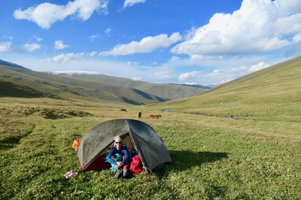
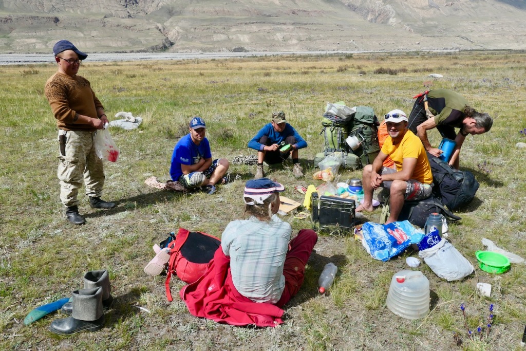
We did this trek late in the season (late August 2019) as a fully supported trek, with guides and horses and porters, all organized by Nomad’s Land in Bishkek. For more details see the logistics section below.
If you go as late in the season as we did, you will have most of it completely to yourself. During our two week trek we hardly met anyone: we passed only a few nomadic settlements on the first half of the trek, and during the second half of the trek we could count the total number of people we saw on one hand. If you go in high season (July and early August) there will be more people, especially on the Engilchek glacier.
Summary of the trek
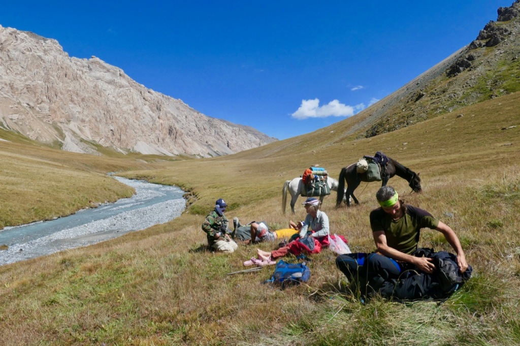
The two weeks of trekking can be divided into three quite distinct sections that could also be done individually as shorter treks.
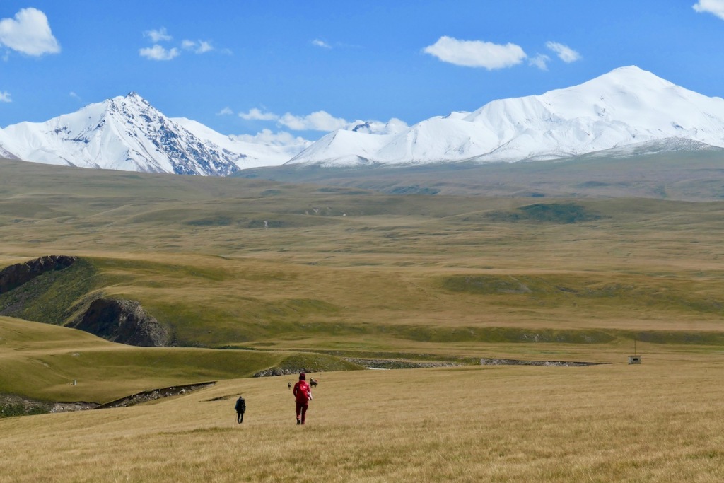
Section 1 (days 1 through 5): Jyrgalan to the Tiup valley, up to the base of the Tyuz pass: rolling green hills with herds and nomads.
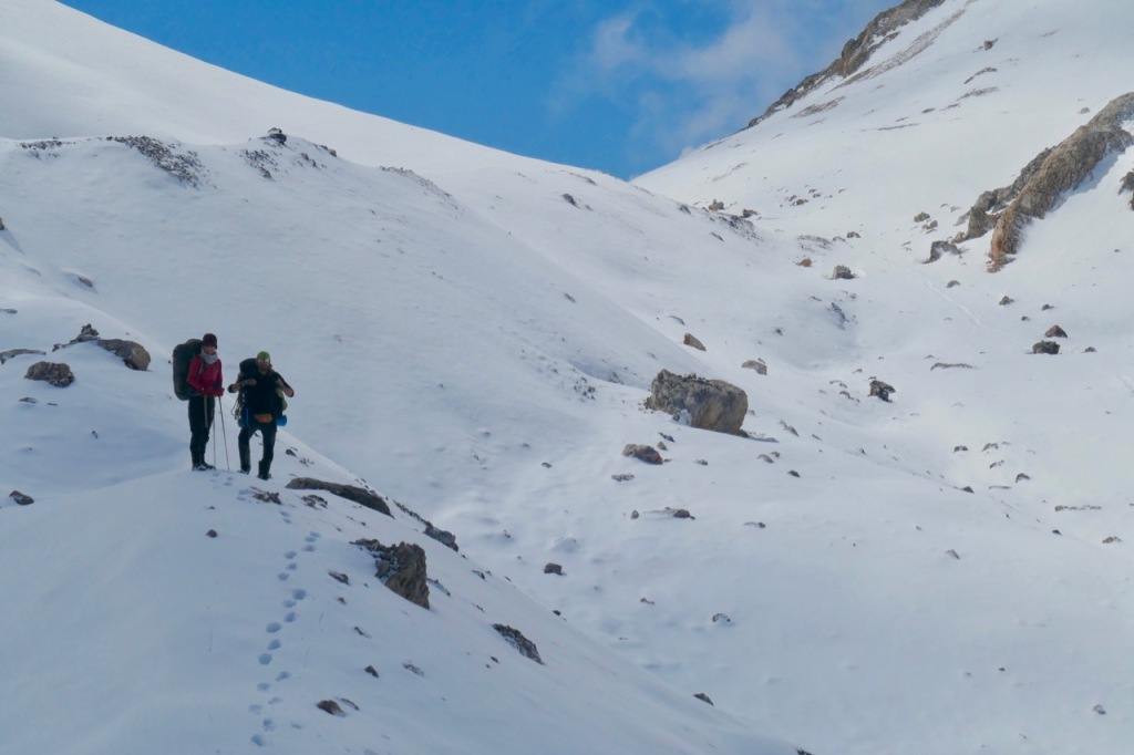
We started our trek in the small village of Jyrgalan, a two hour drive by jeep from Karakol. The first five days we walked through rolling green hills encountering herds of sheep, goats and yaks, as well as a few nomadic yurts along the way. Each day consisted of following a river up to an increasingly high pass and then descending into the next valley to camp.
Section 2 (days 6 though 9): Across the Tyuz pass and up and down the Engilchek glacier: a huge glacier fringed by rugged high snow-covered mountains.
On day six, the landscape suddenly and dramatically changed. We crossed the 4001m Tyuz pass, already covered in 50cm of snow this late in the season, and started our long descent into the Engilchek valley.
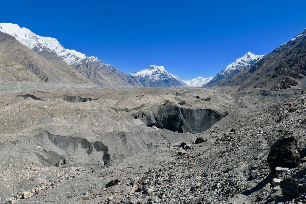
Here we found ourselves in an enormous glacial valley fringed on both sides by steep snow-covered mountains between 5000m and 7000m high. Numerous glaciers tumble down from the mountains, feeding the huge Engilchek main glacier, which is 6km wide and continues a staggering 60 km up the valley to its origin. The breathtaking view looking down from the Tyuz pass upon this spectacle is something I will never forget.
For the next couple of days we hiked on top of the Engilchek glacier itself and on top of the moraines that run parallel to the glacier, and that often tower hundreds of meters above the ice.
If you go earlier in the season, this section may be crowded because several trekking agencies offer a popular trek up the glacier, all the way to Engilchek base camp where you can take a helicopter out. In high season there are fixed basecamps along the route that offer tents and food. When we were there in late August, the camps were already broken up and we saw literally no one on the route.
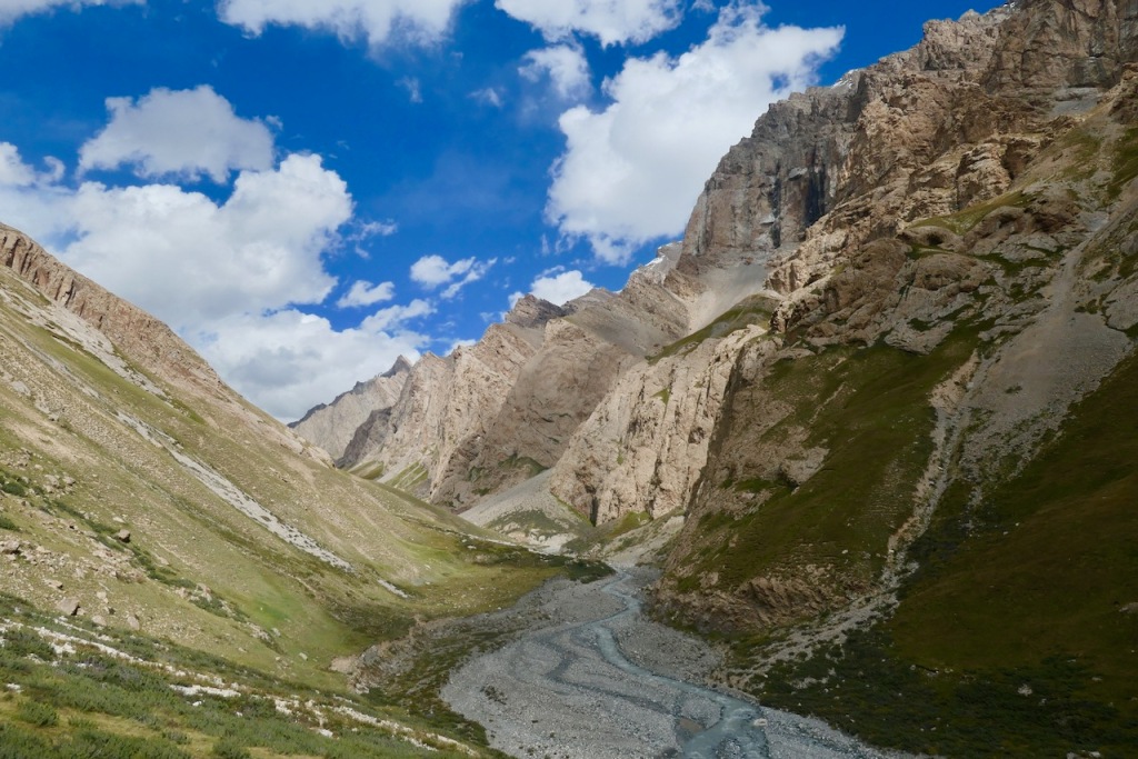
Section 3 (days 10 through 13): Out through the Kaindy valley: high green pastures fringed by glacier-covered mountains.
After coming back down from the Engilchek glacier, the normal route follows the main glacier valley down to Engilchek ghost town. Instead, we did a variation branching off from the main Engilchek valley into the little-visited At-Djailoo valley for three days.
The At-Djailoo valley is kind of a cross between the first section and the second section. Like the first section, the valley itself is a high lush green meadow. But like the second section, it is high and it is surrounded on all sides by high snow-capped mountains with glaciers tumbling down from them.
Detailed itinerary
Day 1 (20 August): Jyrgalan to Tiup valley
At 8am we met our guide Stan and assistant guide / cook Vadim at hotel Matusnoki in Karakol. We picked up some final supplies and started the two-hour drive from Karakol to the small village of Jyrgalan.
In Jyrgalan we met our first horse “man” Cuba, who turned out to be a 14 year old boy (his father was supposed to go with us, but he could not make it). We loaded the supplies and our backpacks on the two horses and then we were off!

Village of Jyrgalan
We started hiking up the broad valley, following a dirt road through rolling green meadows, through light spruce forests, and passing occasional sheep herds and yurts. This mellow rolling green landscape would stay with us for most of the first five days.

Hiking up the first valley

Yurts in the first valley
The road slowly gained altitude until we reached the snow-covered Jyrgalan pass at 3,332m in the afternoon.

Vadim, Bruno, Tecla, Stan, and Cuba at the Jyrgallan pass (3,332m)
Once across the Jyrgalan pass, we started descending into Tiup valley. When we reached the first flat section next to the river, we set up camp for the first night.
Hiking down the Tiup valley

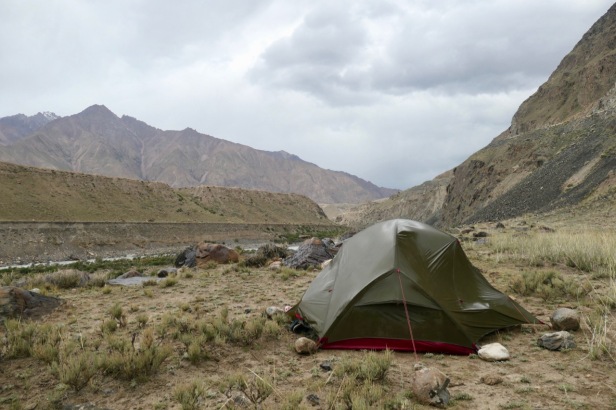
Day 1 camping spot
The first day set the pattern for the rest of the first week: hike up one valley, cross a pass, descend into the next valley, and set up camp at the first feasible spot next to the river.
| Hiking distance / time | 25 km / 7-8 hours |
| Altitude gain / loss | +1000m gain / -400m loss |
| Camping location | Tiup Gorge 2,800m |
Day 2 (21 August): Tiup Valley to Chong Djalangatsh Gorge
The next morning we continued following the river down into the Tiup valley.

Following the river down into the Tiup valley

Horse man Cuba taking a break
After crossing the river and lunch, we started making our way up to the next pass: the 3,660m high Ashu Tor pass.

Guide Stan crossing the river

Cuba, Stan, and Tecla having lunch

Tecla and Vadim at the Ashu-Tor pass (3,660m)
From the pass we continued down into the next valley, where we set up camp for the second night.

Day 2 camping spot
| Hiking distance / time | 17 km / 6 hours |
| Altitude gain / loss | +700m gain / -400m loss |
| Camping location | Chong Djalangatsh gorge 3,100m |
Day 3 (22 August): Chong Djalangatsh to Turuk Gorge
We woke up with ice on the tent and were very happy to have our minus 20 celsius sleeping bags.
After breakfast, we started following the river down-valley until we reached a tiny settlement. There were a few yurts surrounded by large herds of cows, sheep, and goats. The local nomads showed us where to cross the river and invited us for an early glass of vodka, which we politely declined; 9am is a bit too early for us 🙂

Nomads in front of their Yurt

Inviting us for an early vodka
From the settlement, we followed a zig-zagging dirt road up the hill until we reached the Janalach Ashu pass at 3,510m. The pass was gentle and wide with just a little bit of snow.
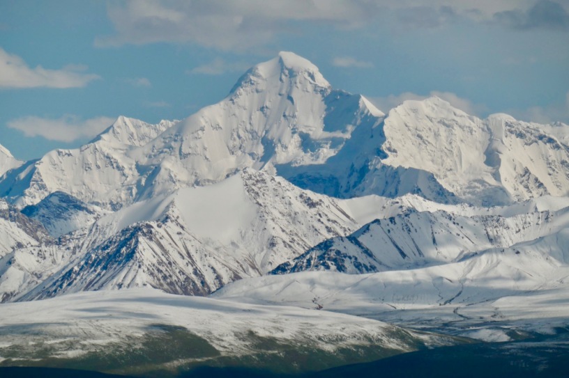
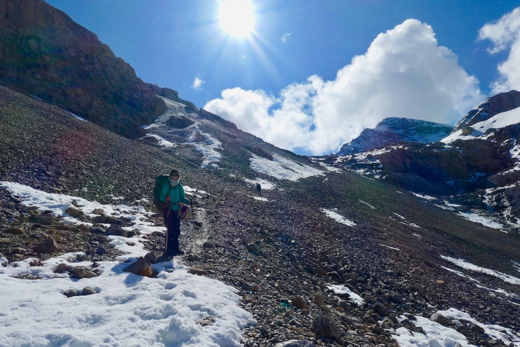
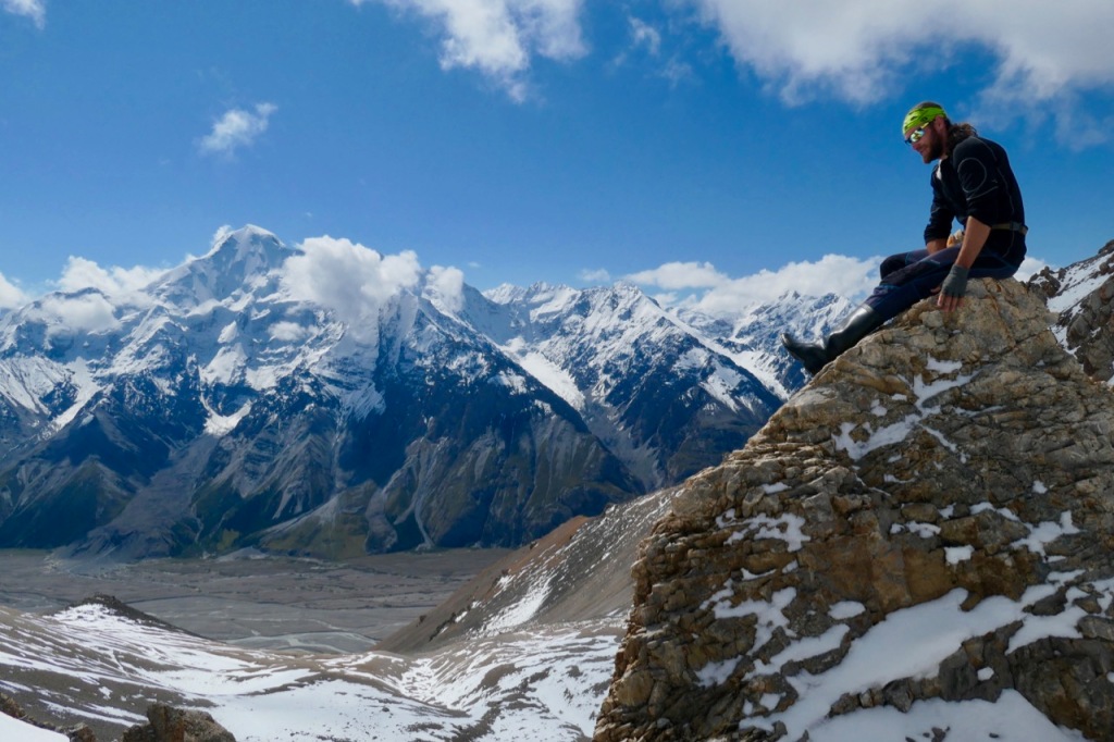
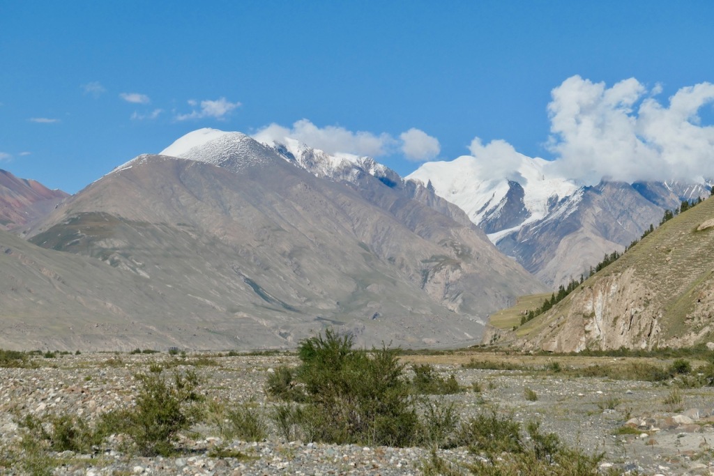
The view from the top of the pass was simply majestic. For the first time we could see the high peaks of Tien Shan mountains spread out in their full glory. The 7000+ meter peaks, covered in deep snow and glaciers, filled the entire horizon. We had lunch and lingered for a very long time to enjoy this feast for the eyes.

View of high peaks from the Janalach Ashu pass

Mountains across the entire horizon
Once we managed to tear ourselves away from the view, we started descending into the Turuk valley.
Our next camping spot was only a short distance down into the valley. To avoid arriving at camp very early (we don’t like short days) our guide Stan suggesting taking a detour following a beautiful snow-covered ridge.

Snow covered ridge
Descending from the ridge we arrived at our camping spot right next to the river.
Day 3 camping spot
Since it was still early in the afternoon, Stan suggested we do another side trip up the steep ridge on the other side of the valley to get an even more majestic view of the Tien Shan mountains (this is actually where the photos above were taken). It took us 3 hours to get up and down, and we arrived just in time before an evening rain shower burst loose.
| Hiking distance / time | 18 km / 6 hours |
| Altitude gain / loss | +600m gain / -700m loss |
| Camping location | Turuk gorge 3,100m |
Day 4 (23 August): Turuk Valley to Echkilitash in the Sary Jaz valley
Once again, we followed the river up valley toward the next pass, which was the Kara-Shu pass at 3,307m in this case.

Following the river up towards the Kara-Shu pass
Just as the day before, the pass was gentle and wide and the views of the Tien Shan peaks in the distance were just mesmerizing. There wasn’t too much snow on the pass, but the ground was wet and swampy.

Tecla enjoying the view from the Kara-Shu pass
Cuba with the horses on the Kara-Shu pass

Guide Stas on the Kara-Shu pass
From the pass we started our descent into the Sary Jaz valley. The mellow green rolling hills of the past couple of days changed into a rocky narrow gorge filled with flowers. In a few places the gorge was so narrow that we had to wade through the river (which was shallow but cold) for some distance. Make sure you bring river shoes (e.g. crocs or sandals) with you.


Flowers

Wading through the river
Eventually the gorge opened up, and we entered a wide open green plain. After passing some large herds of sheep, we arrived at the Echkilitash military base.

Herds of sheep
Wide open green plain before the military base
At the “military base” (which is really not much more than two yurts with a road leading to it) the Kyrgyz army will carefully check your border permit and passport. Make sure your paperwork is tip-top in order and you don’t forget to bring your passport with you.

The “millitary base”
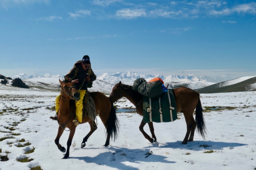
The military checkpoint did not allow our 14 year old horse man Cuba to pass because he did not have any identification papers. Luckily, our cook Vadim knew some of the locals and was able to arrange an alternative horse man for the last couple of days up to the Tyuz pass.
Also, since there is a road to the checkpoint, this is where we met our two porters who would carry the supplies for the four days that we were without horses crossing the Tyuz pass and going up and down the Engilchek glacier.
We had a cup of tea and chatted with some Polish hikers that had just come down from the Tyuz pass while we waited for the formalities to be completed and for our supplies to be transferred to the new horses. The Polish hikers reported that they were stuck on the glacier for several days after an overnight snow storm dumped a meter of snow on them.
Once the formalities were completed and the horses loaded, we crossed the bridge across the Sary Jaz river and started on the last stretch for the day. In a slight drizzle, we continued through mostly flat green meadows, following the Tyuz river (a side branch of the Sary Jaz river), until we reached our camping spot a couple of hours later.

Day 4 camping spot
| Hiking distance / time | 20 km / 7 hours |
| Altitude gain / loss | +300m gain / -500m loss |
| Camping location | Sary Jaz valley 2,900m |
Day 5 (25 August): Echkilitash to Chong Tash below the Tyuz Pass
We woke up to cloudy skies and continued hiking up the valley, following the Tyuz river for a couple of hours.

On the banks of the Tyuz river

On the cliffs above the Tyuz river
The trail meandered up and down, sometimes passing close to the bank of the river and sometime crossing over high cliffs above the river. We passed a few nomad’s houses and lots of herds of long-haired yaks.

A long-haired yak

Passing a nomad’s residence
As we continued, the weather deteriorated: a drizzle turned into a hard rain, which turned into hail, which turned into a driving wet snow storm.
Eventually we reached the side valley which would take us up to the Tyuz pass the next day. Here we had to cross the river, which was a bit tricky: the water was fast, knee-deep, and ice cold.
On the other side of the river, we started a steady ascent in the direction of the pass. The ground was extremely wet and soggy. Sometimes our feet were ankle-deep in water and soon our shoes were soaked and cold. We started to worry that we would not be able to pass the pass if the weather got any worse.

Soggy trail in rain and snow towards the Tyuz pass
After a couple of hours, we reached an open valley with snow-capped peaks and glaciers on all sides and a big waterfall tumbling down. There were some camping spots next to a huge boulder.
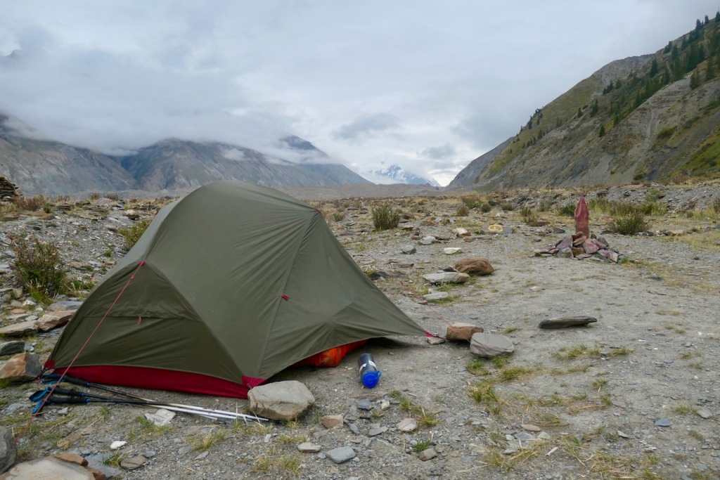
Unfortunately, the most sheltered camping spots were filled with horrible amounts of trash. I just don’t understand how people can seek out such a beautiful remote place and then thoughtlessly leave behind their trash. Luckily, the weather had miraculously improved: the snow had stopped, the sun was shining, and we could set up our tent on a spectacular and clean spot at the top of the boulder with 360 degree views.

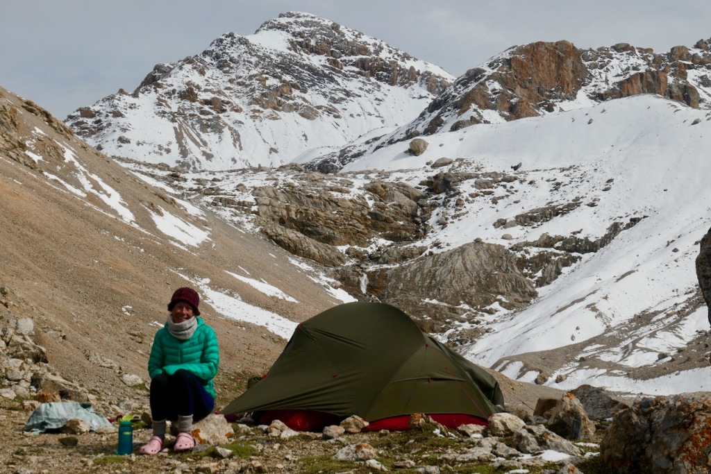

Day 5 camping spot

The huge boulder at the camping spot

View towards the waterfall and pass
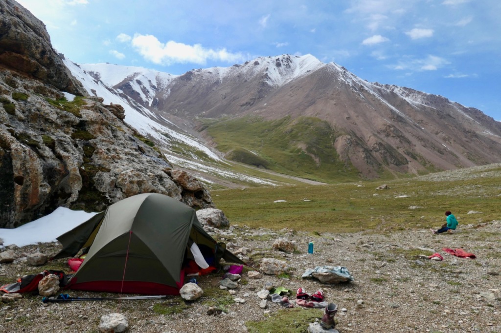
Once camp was all set up, the horse man left with the horses and went back to the military camp. The horses could not cross the pass and could not go up the glacier, so all our supplies would be carried by the porters and the guides for the next four days. Also, for those four days we would carry full backpacks instead of just day packs.
| Hiking distance / time | 27 km / 8 hours |
| Altitude gain / loss | +900m gain / -0m loss |
| Camping location | Chong Tash below the Tyuz Pass 3,885m |
Day 6 (25 August): Chong Tash below the Tyuz Pass to Chong Tash in the Engilchek valley
Day 6, crossing the 4,001m Tyuz pass, was the most spectacular day of the whole trek. A few hours of steep hiking through deep snow culminate in a mind-blowing view from the top of the pass, looking down upon the Engilchek valley, the Engilchek glacier, and the huge mountains that fringe them.
This late in the season, you need a little bit of luck crossing the Tyuz pass. And indeed we were lucky. The weather was absolutely perfect: blue skies. And the snow was easy enough to walk on: a manageable 50cm deep near the top of the pass and neither too soft nor too icy. Of course it helped that Stan and Tecla were breaking trail while I was in the back taking photos.
After a cold night (my boots were frozen solid in the morning) and breakfast, we started making our way up towards the pass.

Breakfast
The trail, which was initially snow free, ascended past the waterfall.
Lucky with the weather
Trail is initially (mostly) snow free

Looking back to the camping spot

Tecla and Stas
We soon turned a corner into a broad valley with a small lake in it.

Valley with lake
From here, the ascent became much steeper and the snow much deeper, about 50 cm. Stas, our guide, carefully picked the best and most scenic route, and broke the trail for us. With the beautiful weather and the scenic views the remaining 1 1/2 hours or so to the pass were actually quite pleasant.

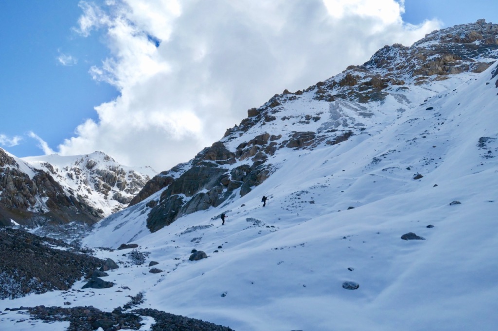
Steeper and more snow past the lake

Stas leading the way

Stas and Tecla


The last stretch to the pass
As enjoyable and as scenic as the ascent is, the real pay-off comes when you reach the Tyuz pass itself. I will admit that I am prone to hyperbole, but this time I think I am not exaggerating when I say that the view from the pass must be one of the best views in the world.
As you reach the pass at 4,001 meters, a literally breathtaking view suddenly opens up. Deep below your feet is the enormous Engilchek valley: several kilometers wide with a wild glacial river running through it. On your left, you see the terminus of the huge glacier itself and you can follow its path for 60 km to its origin on the horizon. Across the valley a splendid range of high mountains covered in snow and feeding glaciers stretches out in all directions. If you are just as lucky with the weather as us, you will have clear views of Khan Tengri at 6,995m, Victory Peak at 7,439m, and Nansen Peak at 5,697m. Words simply cannot do justice to this splendor.

Arriving at the pass

Engilcheck valley and glacier terminus

Bruno, Vadim, Ilya, Tecla, Stas on the pass

Tecla at the pass
Stas at the pass

One of the numerous peaks across the valley
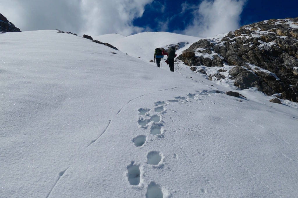
We spent a good hour or so just chilling on the pass and enjoying the views. Meanwhile, our guides Stas and Vadim scrambled up the nearby Tyuz peak which is another 150 meters or so above the pass.
From the pass it is 1,400m vertical down to the valley where we set up camp not far from the terminus of the glacier. The walk to camp is easy but surprisingly long. We took it slowly and stopped for many breaks to savor the unobstructed views all the way down.


On the way down from the pass

Getting close to the camp site

Camp site day 6 with the glacier in the background
| Hiking distance / time | 15 km / 6 hours |
| Altitude gain / loss | +400m gain / -1,400m loss |
| Camping location | Chong Tash in the Engilchek valley 2,879m GPS 42.205278 79.622983 |
Day 7 (26 August): Chong-Tash to Polyana Merzbacher crossing the Engilchek Glacier
Day 7 was another exciting day with spectacular scenery and perfect weather.
We had camped on one side of the valley (the left side of the river when facing upstream, the direction that we were going) but the trail going up the glacier was on the other side of the valley. The river was too deep and too fast to cross by foot, so the first order of the day was to climb onto the glacier itself and to cross to the other side going over the ice of the glacier.
From camp, it was a short walk to the terminus of the glacier where the river sprung from a large cave at the bottom of the glacier.

River springs from glacier
From there it took us about three hours to cross the glacier, following a roughly diagonal route aiming for a large side valley on the other side of the main valley.
Don’t imagine that you will be walking on pristine white snow or blue ice. The glacier is covered with a thick layer (at least a meter) of debris; lots of rocks that have been swept down by avalanches that tumble down from the steep mountains on both sides of the glacier. So, walking on the glacier doesn’t feel all that different from walking on the trail through the moraines next to the glacier.

Walking across the debris that covers the glacier
Since the glacier moves somewhere between 4 and 8 meters every day, the path across the glacier is never the same. Our guide Stas carefully chose a meandering route, constantly going this way and that way to avoid steep ice cliffs and lakes filled with melting water. We passed many ice bridges and ice cliffs where it became clear that there were actually tens of meters of ice below the seemingly mundane surface.


Ice bridges and lakes
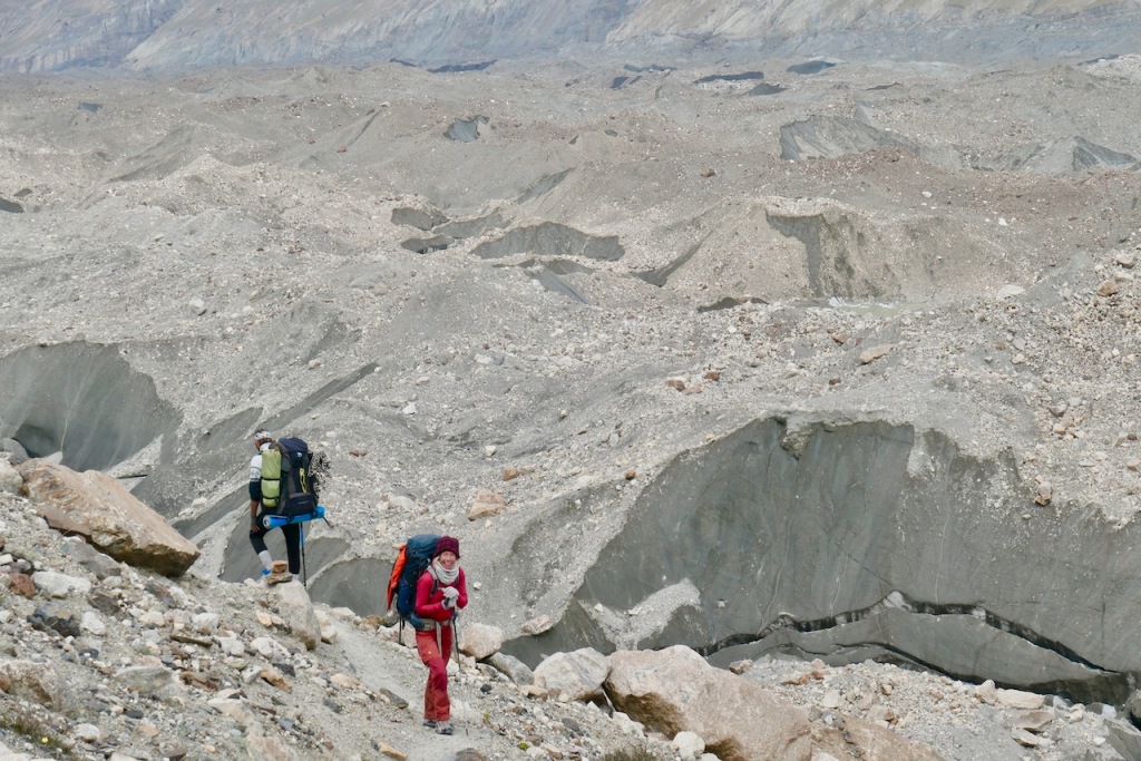
Eventually we reached the other side of the glacier, where the trail continued for another 20 km across moraines on the side of the glacier. Our official itinerary said “today will be a longer day but it’s a very flat day“. Hah! Nothing could be further from the truth. The altitude difference between the start and the end of the day is only 560 meters, but the trail constantly goes way up and way down, sometimes skirting right next to the glacier and sometimes going hundreds of meters above the glacier to avoid some obstacle. Not that we were complaining: the views of the glacier deep below were just stunning.


Views of the glacier deep below
About 2 hours into the ascent we reached a spot where the trail had been swept away and where we had to descend a near vertical section of about 20 meters. Luckily, Stas had brought rope. He set up an anchor, gave us some quick instructions on how to do a Dülfersitz rappel, and down we went.
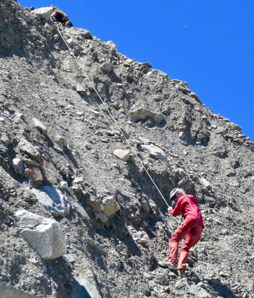
Tecla rappelling
After 12 km / 3 hours and crossing a large side glacier we reached camp Glina, usually the first overnight stop for tour groups going to Engilcheck basecamp. Camp Glina was already abandoned for the season, but we stopped for lunch, filled up our water bottles (potable water is scarce on the glacier), and continued on for the remaining 8 km / 2 hours to our final destination for the day: Polyana Merzbacher. Kudos to our porters and guides for making such long days!

Lunch at camp Glina
As the trail ascended the views of the glacier deep below got more and more spectacular.


More spectacular views
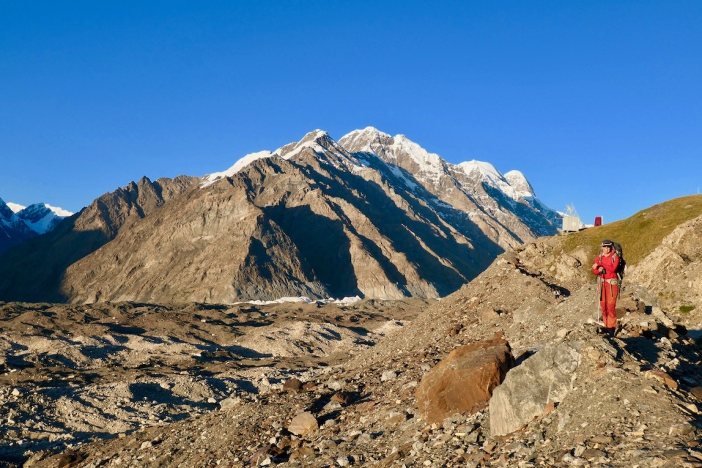
After a long but exhilarating day we finally reached Polyana Merzbacher. This is a research station for climate change: there are container habitats and toilets for the researchers as well as solar panels and antennas. When we got there, there was nobody there. We set up our tent in the back where there is a section reserved for hikers. From where we stood we had a great view of the glacier below.

Polyana Merzbacher
| Hiking distance / time | Estimated: 28 km / 7 hours |
| Altitude gain / loss | Estimated: +1000m gain / -450m loss |
| Camping location | Polyana Merzbacher research station 3,432m GPS 42.165463 79.816016 |
Day 8 (27 August): Polyana Merzbacher to Camp Iva
On the other side of the glacier from Polyana Merzbacher there is a lake called lake Merzbacher. In June and July, lake Merzbacher is quite the spectacle: it’s filled with turquoise water and floating ice bergs. However, each year towards the end of the summer an unusual phenomena occurs: through some mechanism which is not well understood (possibly the rising water lifting up a floating ice dam) suddenly and violently all water pours out of the lake. When we were there, in late August, the lake was already empty.
Our original plan for day 8 was to cross the Engilchek glacier to “lake” Merzbacher, to return to Polyana Merzbacher crossing the glacier again, to go down to camp Glina to spend the night, and then to leave the glacier the next day.
However, our guides were getting quite nervous about the weather. Only one week earlier they had gotten stuck at Polyana Merzbacher due to a surprise storm that dumped over one meter of snow overnight. Their group had to be evacuated by helicopter. The weather was starting to look more threatening, and on top of that there was no helicopter pad at camp Glina. So they strongly recommended that we skip going to lake Merzbacher and descend all the way to the valley the same day, which we did.
It was kind of nuts to hike 28 km up from the valley to Polyana Merzbacher, only to turn around the very next day and hike another 28 km all the way down again. But we did not mind at all: like I said, we love very long days and we love the views. The guide and the porters were good sports about it too, although they teased us mercilessly about being completely crazy.
The way back down was the same as the way coming up, except this time we did not cross the glacier, but stayed on the left side (going down) until we got back to the river. I will just post a couple of photos since the photos from yesterday were better because of the clearer weather.


Coming down the glacier
When we got to the section where we had rappelled down the previous day, Stas found a way to avoid the cliff by taking a detour across the glacier itself.
Just before reaching the terminus of the glacier, we passed a small lake with small chunks of ice floating in it. Here we spent an hour or so relaxing to enjoy the last views of the glacier and to avoid arriving at camp too early.

Lake with ice
After leaving the glacier we walked another hour or so alongside the river to reach camp Iva, our camping spot for the night.

Camp Iva
| Hiking distance / time | Estimated: 28 km / 6 hours |
| Altitude gain / loss | Estimated: +450m gain / -1000m loss |
| Camping location | Camp Iva 2,899m GPS 42.191545 79.636931 |
Day 9 (28 August): Camp Iva to At-Djailoo River
Day 9 was a short day in terms of hiking distance, but we had some logistics to take care of.
First of all, we were going to meet our new horse man, Jardarr, with two new horses. While we were waiting for him to arrive, we slept in and had a late breakfast.

A late breakfast
When the horse man arrived in the late morning, we packed up all our gear and started hiking the easy 13 km to the next camp just down the valley.
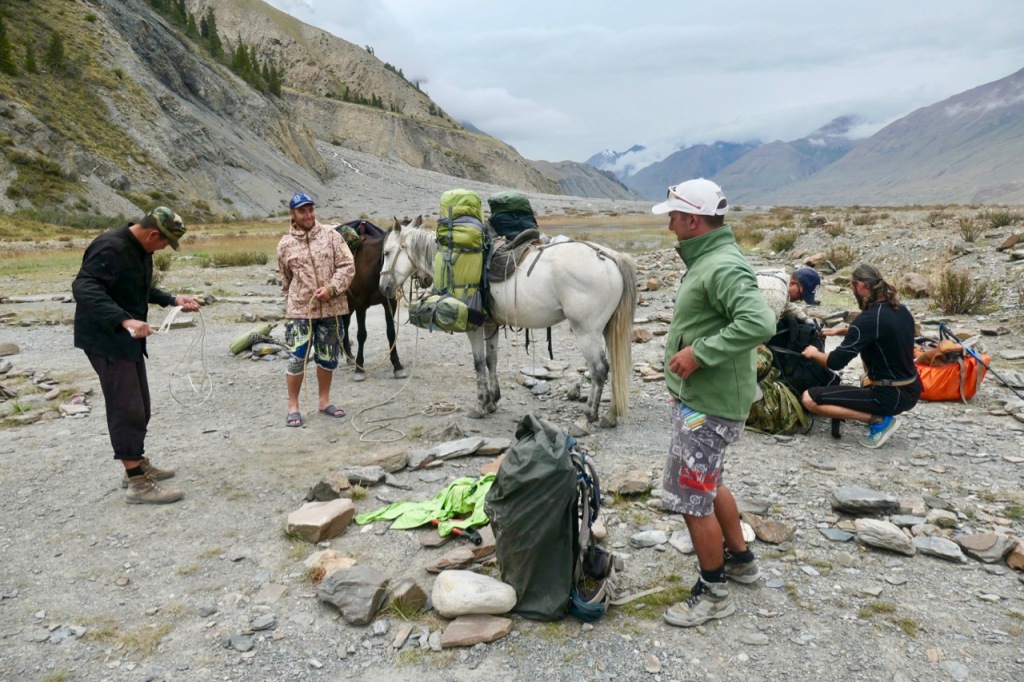
Loading the new horses
The terrain was easy and flat, essentially just following the left side of the river walking down-stream. There were some nice views into side valleys and for the first time in a long while we saw some trees.


Side valleys and forests

Berries that can be used as lip balm or eaten
We took it easy and enjoyed the views because we knew it was going to be a short day. We even stopped and joined the guides and porters for a very elaborate lunch where Jardarr shared some delicious freshly roasted Ibex meat from a hunting trip that he had just finished.
Lunch
After just a couple of hours we reached the camp spot, which was located just a short distance before the entrance of the large side valley from which the At-Djailoo river came down and joined the Engilcheck river in the main valley.
The trekking agency had sent a four wheel drive jeep to deliver new supplies and to pick up the porters to return them to Karakol. The jeep would meet us a few kilometers further down the valley where the “road” ended.
We set up camp, said good bye to the porters and tipped them and used the rest of the afternoon to explore the surroundings of the camp, in particular the beautiful entrance to the side valley.

Day 9 camping spot
Meanwhile, the guides, the porters, the horse man, and the horses left us for a couple of hours to meet the jeep, to pick up the supplies, and to drop off the porters.
| Hiking distance / time | 13 km / 3 hours |
| Altitude gain / loss | +0m gain / -0m loss |
| Camping location | At-Djailoo River 2,742m GPS 42.161075 79.486126 |
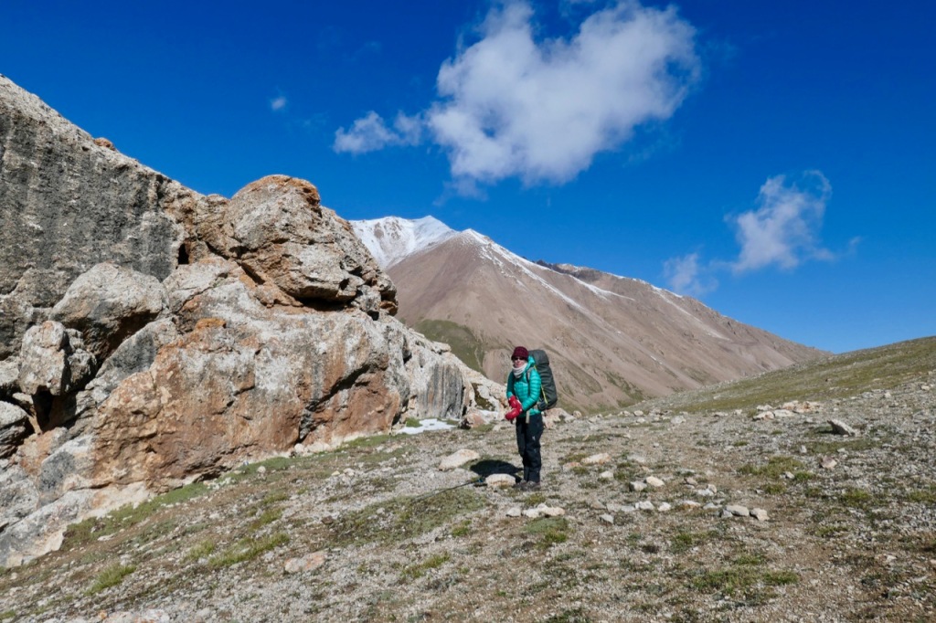
Day 10 (29 August): At-Djailoo River to the At-Djailoo pass
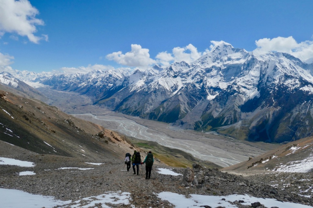
On day 10 we entered the third and final phase of the trek. After the rolling green hills of the first five days and the huge Engilchek glacier of the next four days, the landscape dramatically changed again.
We entered a green valley that started out wide but that became increasingly narrow until it ended in a spectacular narrow gorge at the end of the three days. The valley is fringed on both sides with high snow-covered mountains, glaciers, and side valleys.
The first order of the day was to cross the At-Djailoo river. Since the river was too deep and fast to cross by foot, we crossed it by horse.

Crossing the river by horse
We entered the At-Djailoo valley and started a steady ascent over green meadows. We crossed the At-Djailoo river again (over a bridge this time) and after passing through a small grove of trees, we continued our ascent up the meadows leaving the river far below us on our right side.
As we quickly gained altitude, the views became more and more spectacular. On our left side was a fork in the valley with a glacier. We turned right, and headed into the other fork.


Going up green meadows

Crossing the river again


Sides of the valley
We had a very elaborate lunch on a green hill for the last views back to the Engilchek glacier from where we came. Jardarr, our new horse man and avid hunter, shared some horse meat and some other pieces of meat that were delicious but quite unusual: essentially pure fat.

Cook Vadim 
Lunch
This particular valley is not used for trekking very much; it is more popular with hunters. Further up the valley, we passed several Ibex horns that were evidently left behind by hunters or wolves.

Ibex horns
We crossed a side river of theAt-Djailoo river one more time, over a snow bridge this time.
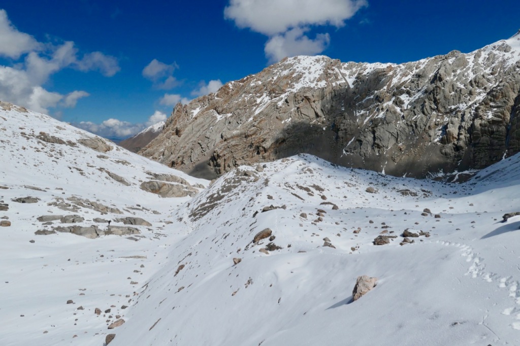
As we continued up the valley, and as the terrain became flatter, it also became very soggy and swampy. When we reached the lake at the top of the “pass” we found ourselves on a huge flat meadow that was almost a bog: very lumpy chunks of stiff grass separated by small pools of water.
It was nearly impossible to find a camping spot. A few hundred meters left (South) of the lake, there was a small hill that had some dry spots. Still, the ground was very uneven and lumpy, making for an uncomfortable night of sleep.
The discomfort was more than compensated for by the views: our tent was literally at the foot of the snow-capped and glacier-covered ridge of mountains that fringed the pass.

Day 10 camping spot


Views from camping spot
| Hiking distance / time | 12 km / 4 hours |
| Altitude gain / loss | +900m gain / -0m loss |
| Camping location | At-Djailoo pass 3,657m GPS 42.109608 79.434006 |
Day 11 (30 August): At-Djailoo Pass 3,674 m to Kaindy Valley
Day 11 was a long day. The first 18 km or so we descended west and then south-west, following the small river that sprang from the lake. The guides followed the river itself, but we found it tiresome to walk on the stone boulders, so we often chose a higher router over the grass where there was an actual trail.


Continuing down the At-Djailoo valley
Lunch

More glaciers
Initially, the valley was wide and green, flanked on both sides by snow-covered mountains with an occasional glacier. But as we continued down the valley it got narrower and narrower, until it became a very narrow canyon with steep walls on both sides. Our trail went higher and higher to avoid the steep cliffs further below.


Gorge
After six hours or so of walking we exited the gorge and entered to much wider Kaindy valley. Here we turned right (East) and started following the much very wide and swift Kaindy river.

Entering the Kaindy valley
The horse man and the horses followed a low route, occasionally having to cross the river to avoid cliffs. We followed a much higher route because the water was way too deep and wild to cross by foot.
Eventually we also descended to the river level and ran into an abandoned road that appeared to be from the Soviet times. It clearly had not seen any traffic for many years, but there was still a sign.

Optimistic road sign
As the valley reached a wide turn towards the left, we started running into the first signs of civilization again: some abandoned farm houses, and even one or two that seemed to be in use.
After about 8 hours of walking, as a ferocious thunderstorm broke loose and the rain started pouring down on us, we started wondering how much further we had to go. It seemed to us that we had already passed several fine camping spots.

Rain
The mystery was soon solved: we reached a large farm that turned out to be the house of Jardarr, our horse man. As soon as he had coverage he had phoned his wife and planned a surprise dinner for us! We set up our tent on the meadow next to his farm, where we met two trekkers from Austria who had also set up a tent there. And then we joined Jardarr and his family in their dining room for an absolutely wonderful dinner and some shots of vodka.


Jardarr’s farm

Dinner
And that wasn’t the only surprise. Jardarr also had a traditional Kyrgyz sauna in his backyard. It was a little house where a wood-fired boiler produced boiling water which you could mix with cold water and then pour over yourself. I think I must have spent an hour in there – it was simply blissful to be able to wash myself for the first time in 11 days…


| Hiking distance / time | 29 km / 8 hours |
| Altitude gain / loss | +0m gain / -900m loss |
| Camping location | Jardarr’s house in Kaindy valley 2,753m |
Day 12 (31 August): Kaindy Valley to the lower Kaindy Valley
Before heading for our last day of hiking, we spent some time looking around on the farm and observing how the family butchered two of the goats from their herd.

Butchering goats
Instead of using his horses, Jardarr used his classic Soviet-era truck to transport our supplies for the last stretch. He offered us a ride, but we preferred to walk to make the most of our last day of hiking.

A ride on Jardarr’s truck
We started walking down the dirt road that was barely more than a trail. As we descended down the valley, we passed the last of the snow-capped mountains. The first signs of civilization started appearing: pretty little farm houses set amongst the pretty groves of the first deciduous trees, some goat herders with their flock, and a small abandoned Tungsten-mining town from back in the Soviet days.

Last views of the mountains

First farms

First groves of trees

Tiny abandoned Tungsten mine

Sheep herder
We crossed a half-collapsed bridge, and when we reached a completely collapsed bridge some distance later, Jardarr shuttled us across the raging river in his big truck.
The “Road” high above the river

Semi-collapsed bridge
We had lunch in the shade of a tree on the other side of the river, and then crammed into a tiny Lada 4×4 car together with Stas and Vadim and our remaining supplies to drive the last little bit to the hot springs.

Tiny 4×4
The hot springs are evidently quite popular. When we arrived there were several other cars there, but they all soon left as it started raining. In the winter months there are supposedly hot springs in the river it self. But when we were there in late August there were only two hot springs enclosed by walls built up against the cliffs. The water was quite hot and clean (not stinking of sulfur or filled with slimy substances like most other hot springs) although there was quite a bit of trash around (which Stas collected and removed). We spent the rest of the afternoon soaking in the hot water.
Day 12 camping spot
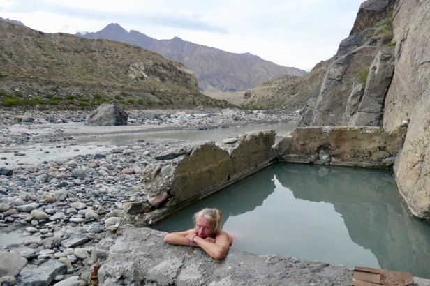
Hot springs
| Hiking distance / time | 12 km / 3 hours walking 8 km driving |
| Altitude gain / loss | +0m gain / -300m loss |
| Camping locating | Hot springs 2,463m |
Day 13 (1 September): Transport from Enilchek village to Karakol
The last day! At 10am a 4×4 (thankfully much bigger than yesterday’s Lada) came to pick us up for the 6 hour drive back to Karakol.

Jeep back to Karakol
Along the way we stopped in Engilcheck, a large abandoned mining ghost town. Back in the Soviet Union days 15,000 people used to live here, employed at the large mining complex. When the Soviet Union collapsed, the city was abandoned, seemingly overnight. There are rows and rows of empty houses and even multi-storey apartment building, all eerily empty and crumbling. You can enter the apartment buildings, and some of the rooms still have shoes or cutlery or other belongings in them. These days, there are one 20 or 30 families left in the entire city.


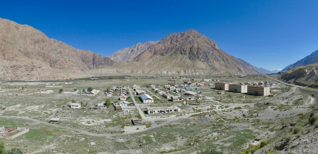
Engilcheck gost town
Logistics
As I mentioned at the beginning, we did this trek as a fully supported trek, with guides, horses and porters, organized by the excellent travel and trekking agency Nomad’s Land in Bishkek.
Can you do this trek independently without guides and porters? I am not one to tell you what you can or cannot do. But unless you are a super experienced and strong hiker with very confident navigation skills, I would not recommend to attempt to do the entire 13 day trek by yourself. You will somehow need to organize the required permits. You will need to bring in and carry all supplies for 13+ days (there are no resupply points except the fixed camps on the glacier in high season only). You would have to organize transport to and from the hike (there is no public transport and it is a 6 hour drive to Engilchek town). And you must bring an excellent map and/or GPS tracks, since there are no trails on some sections. That said, we did in fact run into two independent groups of foreign hikers that did some part of this trek, but not the entire trek.
Our contact at Nomad’s Land was Alex Johnson (alex@nomadsland.ch), an American now living in Bishkek. At Nomad’s Land he is responsible for designing custom trips and treks in Kyrgyzstan. He also runs “UAZ Buhanka Rental”, a company that rents out classic Soviet UAZ 4×4 vans and jeeps. We definitely plan to return to Kyrgyzstan and Tajikistan next year and rent one of his vans for several months of more exploration.
We had simple instructions for Alex: we were looking for a two week trek, as remote as possible, with full days of 7 to 8 hours of hiking per day, but without any technical climbing. We wanted to keep our backpack weight down to less than 15kg, so that meant that we would need horses and/or porters to carry the equipment, supplies, and some of our luggage. Alex went to work, and came up with the itinerary that is described in this blog.
If you take this itinerary as inspiration for your own trek, you should be aware that Alex really did take our wishes to heart: he really did come up with a trek that had very long days. Most of our days really did cover 20km to 28km, and the longer days also involved up to 1,200m vertical up or down, sometimes through 50cm deep snow carrying backpacks. We typically started hiking around 9:00am or 9:30am and rarely finished before 4pm or 5pm. If you are an experienced hiker who likes making long days, then this itinerary should be perfect for you. If not, you might want to consider adjusting the itinerary and trimming the daily distances down to 12km to 15km per day, which is actually the norm for organized treks in this area.
To do this trek you need a special permit to enter the restricted zone along the Chinese border. Nomad’s Land will take care of all the paperwork, but it takes two weeks to obtain this permit. Some trekking agencies in Karakol will claim they can get a permit in as little as three days, but in our case it actually took the full two weeks to get the permit, so buyer beware.
Also, particularly in the high season, experienced English speaking guides and horsemen are in very limited supply. Plenty of guides know the popular routes close to Karakol such as Ala-Kul lake and the Engilchek glacier, but very few know the off-the-beaten remote routes such as the first and third section of the trek described in this blog.
Because of the permit and because of the limited availability of guides, you really should contact Alex at least one month before the start of the trek to allow for enough time to plan the itinerary and get the necessary permit. We actually contacted Alex only two weeks in advance, and Alex had to work some minor miracles to get the permit in time and find us a guide (sorry Alex for nearly driving you crazy in the process).
Alex came up with a 13 day itinerary that is described in detail above. He also organized a guide, an assistant guide / cook, horses with horse-men to carry the supplies, porters to carry the supplies for the sections were the horses could not go, and jeeps for transport to the start and from the end of the trek. See the crew section below for details.
The crew
The guide: Stas


Stas
Our guide was Stas (Instagram stas_mountain_guide), originally from Kazakhstan but now living in Bishkek with his Kyrgyz wife and his one year old son. We have had many guides on many treks and I can say that Stas was without doubt the best guide we have ever had. He was a friendly, calm, confident, and very experienced. He loved hiking long distances, and even if we wanted to add an extra side trip for a better view after an already long day, he was always enthusiastic about it. On difficult sections he was patient and helpful, for example fixing a rope to rappel down a steep cliff, or seeking an alternative route over the glacier when we ran into a section where the trail was washed away.
The assistant guide and cook: Vadim


Vadim
Vadim Karaulnyh (Instagram vadima_kg) was the assistant guide and cook. In terms of personality he was the opposite and perfect complement to Stas: he was outgoing and flamboyant. He was also a very experienced mountaineer and he loved extreme sports such as helicopter skiing (in fact he was the skiing champion of Kyrgyzstan), climbing, paragliding, surfing, etc. He took his duties as cook extremely seriously, using only fresh ingredients and spending hours each day to prepare the perfect meal. For example, he even brought a percolator and real Italian coffee along so that we could have fresh espresso each morning.
The first horse “man”: Cuba

Cuba
Cuba was our horse “man” for days 1 through 4. I put “man” in quotes because he was a very young lad, just a kid really. His father was supposed to go with us, but he could not make it for some reason unknown to us, so he sent his son Cuba instead. This was Cuba’s first long trip as a horse man, and although he seemed a little bit nervous, he did wonderfully. Unfortunately, his permit was not in order when we got to the military checkpoint, and we were very lucky that Vadim was able to quickly arrange a temporary replacement horse man for days 4 and 5 (sorry, I forget his name). Also, once Cuba gains more experience he will be able to provide more help to the guide and assistant guide in terms of camp duties.
The second horse man: Jardarr

Jardarr
Jardarr was our horse man for days 9 through 12. He was super experienced and knew the mountains inside out. He has a friendly and gently man. He was also an avid hunter who loved to share delicious game meat from his recent hunting trips with the entire group. On day 11 he surprised us by very kindly inviting us to his family home to have dinner with his family and to camp on the grass field next to his house.
The porters: Daniel and Ilya

Daniel and Ilya
Daniel and Ilya were our two porters for the middle section (days 6 through 9) where the horses could not go. Originally, we were not planning to have porters, but we added them last minute. It was amazing how much these guys could carry! They were always cheerful and never complained about the fact that they had to hike such long distances (much more than what trekking groups normally hike per day).
Things to reconsider
We absolutely positively loved this trek. In fact, it was one of the very best treks we have ever done. Still, there are a few things that we would have done differently in retrospect:
Plan for porters or communicate clearly to make sure that everyone is on board with not having porters. Our original plan was not to have any porters. Our plan was for the guide, the assistant guide and the two of us to carry all supplies without any porters from day 6 until day 9, when crossing the Tyuz pass and going up and down the Engilchek glacier, where the horses cannot go. This turned out to be impossible. When we started the hike on day 1, it was immediately obvious that we had waaaay too much “stuff” to carry with just four people and no horses. The horses started with probably 100 to 150 pounds of supplies plus 2 x 25 pounds for our backpacks. On top of that, the guides were each carrying 50+ pound backpacks. Even considering that we would consume part of the supplies, it seemed impossible to carry it ourselves. Alex and us had talked about this, and we had decided to travel super light for the middle days. But somehow this message did not get clearly communicated to Vadim, who had consequently packed normally instead optimizing for ultra light-weight. Luckily, I had my InReach satellite messenger and I could communicate with Alex at the Nomad’s Land office and arrange for two porters to meet us at the military base (at an extra cost to us). The moral of the story is: either just plan to bring porters from the get-go. Or if you do want to carry everything yourself for the section where there are no horses, then make sure that everyone is aware of that plan and packs accordingly.
Consider bringing 3 horses. As I mentioned, both Stas and Vadim were carrying 50+ pound bags, even on the sections where we did have horses. It would have made sense and added little extra cost to bring one more horse, so that they could travel lighter.
Make sure everyone, including horse men and porters have permits. We had a little panic when our first horse man, Cuba, was not allowed to pass the military checkpoint because he did not have the proper paperwork. It ended well because Vadim had friends there and could arrange an alternative horse man (at no extra cost to us). But that was pure luck, and it could have been much worse. Make sure that you check and double check that everyone in the group, including the guides, the horse men, and the porters have valid permits and IDs.
Consider going a bit earlier in the season. We went very late in the season. I certainly think it is a good idea to avoid the high season, and hence the crowds on the Engilchek glacier. But it is also a bit of a gamble to go so late in the season. By late August the weather is already very unpredictable and you can get heavy snow storms on any day. In fact, just the week before our trek, Vadim had led another group up the Engilchek glacier; they got several meters of snow dumped on them overnight in a freak snow storm and they had to be evacuated by helicopter (about $5,000 to be paid immediately). When we got there just a few weeks later, the snow was already gone. In fact, we were extremely lucky: we had almost perfect weather conditions for the entire 13 days. Still: Vadim and Stas were always very nervous about the weather, and we cut down our time on the Engilchek glacier by one day for fear of getting caught in a snow storm like Vadim’s previous group.
Make sure everyone is aware of the itinerary. We asked Alex for long hiking days (20-30 km and 7-8 hours per day). We were extremely happy and satisfied that Alex actually delivered an itinerary with the long days that we had requested. We also had a preparatory conference call with Stas where we discussed our desire to have long days, so he was aware of it as well. But I get the impression that Vadim and the porters were caught off-guard by the unusually long days. After the initial shock, they handled it wonderfully with humor, even teasing us mercilessly about that “crazy Dutch couple”.

Hi Bruno,
Thanks so much for this write-up, I’m very tempted to do this trek. There aren’t a lot of reports on this specific approach, since most people take the helicopter. I am especially interested in attempting it independently this year – although challenging, it does look doable. I do have a few questions about the trail though, in particular about some of the trickier sections, namely:
– The At Jailoo river crossing. I understand this is a dangerous one, which you can only cross in the morning (and even then its touch and go). Did you feel that way?
– As I understand, the trail up the glacier (to camp glina and further) are somewhat optional side treks, is that right?
– Would you by chance have the gps coordinates of the entire trail?
Finally, would you be able to give me the email address of the agency that organized it for you? I tried messaging through their website but didnt get a reply yet.
Thanks!
Rohan
LikeLike
Hi Rohan,
Yes, the At Jailoo river is fast flowing, ice cold, and tricky. We crossed it by horse at 10:30 am in late August. At that time, the crossing was about 30 meters wide, and about 50 cm deep (about knee deep for the horses as you can see on the day 10 photo on the blog). I liked having the horse, but I feel it is just doable on foot if you are experienced and super careful. Make sure you bring river crossing sandals or shoes, you definitely don’t want to attempt this bare foot. Earlier in the season, where there is more melt water or after heavy rains it may be MUCH more dangerous.
As far as the glacier is concerned, we only went as far as Polyana Merzbacher. That already involved some significant glacier walking. We had to cross the glacier one side to the other once (this is several km and took the entire morning). And we also had to walk on the edges of the glacier for several stretches. Route finding is non-obvious and there are crevasses to look out for. For example, there was one land slide that we rappelled down from on the way out (see photo day 7 on blog) and circumvented back taking a wide detour across the glacier on the way back.
The camps beyond Polyana Merzbacher are much more difficult in the sense that it is mostly glacier walking from there on. Only attempt this solo if you are an expert navigator and if you have extensive experience solo hiking on glaciers (if not, take a guide). And yes, if you are not talking the helicopter out at the end, these extra camps will be optional since you will be doing an in-and-out hike anyway.
One thing to keep in mind is that things can become very dangerous and difficult when there is significant snow fall, which can happen any time of the year. This applies to the entire glacier section, even the part up to Polyana Merzbacher. Just a couple of weeks before we were there, another party got surprised by several meters of snow, and they had to be evacuated by helicopter.
The company that organized the trek for us was Nomads Land:
Web: https://nomadsland.ch
Email: info@nomadsland.ch
WhatsApp +996777565420
Phone: +996 312 964666
The person at Nomads Land who worked with us to organize the trip was Alex Johnson (https://www.linkedin.com/in/alexjohnson76/), but he since moved back to the USA and I think he no longer works for Nomads Land.
I did not record the trek, so unfortunately I don’t have any GPS track to share.
Have fun, this is an epic hike, one of our very favorites! We have been planning to come back to Kyrgyzstan for some more remote hiking, but this has been postponed to 2022 due to Covid.
— Bruno
LikeLike
Thanks Bruno! As I’m thinking of going this season, I got in touch with another agency (Kyrgyz Nomad – funnily enough there is an Alex there too), and they too seem to think it’s manageable solo. I was also able to find the GPS tracks from another pair that did the same trip independently, and even went all the way up the glacier to base camp. The pictures are simply otherworldly (http://world-wild-camp.com/inylchek-kirghizistan), but from my experience and the photos I can already tell I would only be comfortable going solo up to Merzbacher.
I’ve done a fair few wild river crossings in the high mountains so I know what they can be like, and it’s the one thing that makes me apprehensive. 50cm depth seems doable though, provided the weather is good and the Merzbacher lake doesn’t discharge.
Hope you make it back next year! As you are probably aware, Tajikistan next door has some amazing hiking trails too, many of which can be done independently. I went in 2019 and would like to return again at some point. If ever you want any information about some of the trails there I’d be happy to help.
Thanks again
Rohan
LikeLike
Hi Rohan,
That world-wild-camp blog is awesome; great photos and lots of inspiration for trips! Thanks for sharing!
Tajikistan is definitely on our list of places to go. We were planning make a loop from Kyrgyzstan to the Pamir highway in Tajikistan to Uzbekistan and back to Kyrgyzstan in 2020, but that got postponed because of Covid. If you have any hiking suggestions I would be very much interested.
— Bruno
LikeLike
Hi Bruno,
I meant to reply much sooner, but with all the preparations for my summer trip it fell by the wayside. Very happy to say that I managed to do this trek solo last month! Your blog description was really helpful for this, especially the first part – as you say, it’s not so well known. I initially meant to follow your itinerary for part 2 & 3 also, but ended continuing (almost) all the way up to base camp after Merzbacher because I really wanted to get a view of Khan Tengri and Pobeda. I stopped just a couple of kms before B.C. because of a tricky crevassed zone, but I could already see the big peaks from there, so was pretty happy. It did mean that I couldn’t do the 3rd leg though because of low supplies, so I just went straight down the main valley to Engilchek village. In fact I would have had to cut the trip shorter as I only had about 13 days of food on me, but by a stroke of luck at Merzbacher I met another tour group who were happy to share some of their extra supplies with me, so I could make it all the way up. In the end I must have spent nearly a week on the glacier, since I did shorter days up & down and also spent a couple of days doing day trips from Merzbacher. Total trek duration was 18 days so that return shower did feel good 🙂
I think I was a little luckier on the weather front, since there was no snow on the Tyuz pass when I crossed (although I could see snow on it in the days after I crossed). And no major blizzard on the glacier either (which was my biggest worry). The daily thunderstorms were pretty stressful though – I didn’t realize how unstable the weather is there! I was starting to get to me after a while, but oddly enough it was much more stable at the head of the glacier than on the grasslands, meaning that I could have longer days there. The At-Jailoo river wasn’t such a big deal in the end since I timed it for the morning & the weather was OK. The Tyuz river on the hand was tougher – I crossed in the late evening, and was very much at my limits.
All in all, definitely one of my top (and toughest) treks, so very glad I did it. For years it had been on my list, but I had long thought it was impossible to do solo. Again, great job with the description, so thanks!
Rohan
LikeLike
Congratulations 🎉 on finishing the hike solo; I am really glad that you enjoyed it!
LikeLike
For Tajikistan, I actually used the guidebook – Trekking in Tajikistan (published by Cicerone) – which gives a very comprehensive overview of over 20 medium to long treks. I did one of the big lake treks, where you spend practically every day near one azure blue lake or another, among the snow-capped peaks. It’s a very nice and moderate 8-day trek over 120km, where you cross a couple of passes over 4500m, including one that’s covered in a small glacier. The mountains do become increasingly imposing and snow -laden the further you go along the trek, though not as clustered together as around Engilchek glacier (for that you have to go the Fedchenko glacier, which is much, much more inaccessible). As a result, I would say it doesn’t have the same wow-factor as Engilchek, but it’s a very pleasant one nonetheless. The weather is much more stable and it’s much drier though, so the scenery resembles Ladakh more at times. Are you on facebook? If so, I’d be happy to give access to my photos (I only post pictures from mountain trips nowadays), as I have never really found the time to do blogs. I also did another side trip that was closer to the heart of Pamirs – which you won’t find in any guidebook – and which is much more spectacular. It’s actually the first leg of the trek that crosses the Fedchenko, and I hope to return one day to complete it (though for sure I cannot do it solo). Again, pics are on FB so don’t hesitate if you want more information.
On another note, have you considered the Dhaulagiri circuit in Nepal? I did it over 9 years ago, but it’s honestly hard to beat – this trek is the only one I have done since that is on a par with it. Although it’s much shorter (around 100kms), the altitude variation is extreme – from 900m to 5300m. On the way it goes through tropical forests, temperate forests, alpine meadows, glaciers – including Dhaulagiri B.C – and eventually high mountain deserts across the Himalayas that resemble Tibet. I don’t know if the route has improved since I did it, but I can tell you it was very wild in parts, which adds to the sense of difficulty and remoteness – a far cry from the crowds of the Everest trail. And the views – especially at the top – are some of the finest anywhere. Like the Tyuz pass, except the mountains are 7 & 8000ers.
Hope that helps, happy to provide more info if you need!
Rohan
LikeLike
I did not know there was a Cicerone guide for the Tien Shan mountains; I will check it out!
LikeLike