
And now for something completely different! We normally prefer remote hikes in the high mountains, wild-camping in the backcountry and generally avoiding other people as much as possible. But when a planned hike in Norway was scuttled due to a two-week forecast of torrential rain, we had to come up with a new plan for a hike in Europe on short notice. After much Googling for search terms such as “off the beaten track” and “remote hike Europe” we stumbled upon the Peaks of the Balkans trek.
This is a 200km trek that straddles the borders of Albania, Montenegro, and Kosovo. After reading the description of this hike (mainly on the Uncornered Market blog and on Zbulo travel agency website) we were immediately intrigued. It had all the ingredients of a great mountain hike with a large serving of cultural elements as a bonus. As far as nature and mountains is concerned, the trek passes through the very beautiful Accursed Mountains, so named because of their wild and impenetrable appearance. But you also pass through quaint little villages stuck in times long gone, as well as larger more modern towns with restaurants, bars, and cultural attractions.
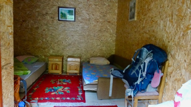
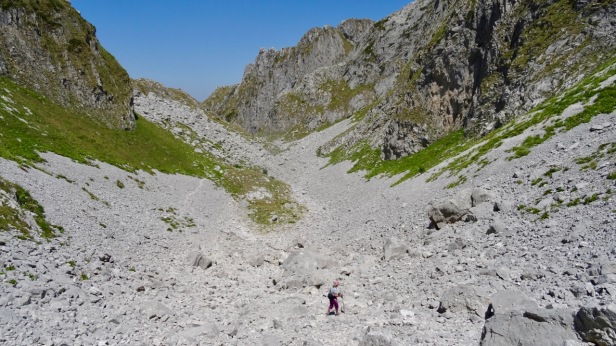
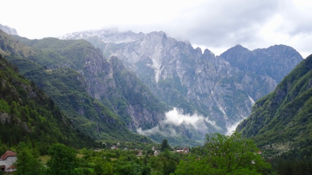
Photos
Start and End Point
If you hike the complete Peaks of the Balkans, it is a circular trek where you end at the same point as where you started. There are a couple of options for where to start and end the trek.
The first option, which we picked, is to start and end in the small town of Valbone in Albania. This involves flying into Tirana, the capital of Albania, and then taking a public bus to Shkodër, and finally a combination of a minibus, a ferry, and another minibus to Valbone (more details below).
A second potential starting point is the small town of Teth in Albania, which is just one stage before Valbone. This is how the trek is described in many guidebooks. It may be easier to get to Teth (I am not sure) but the trip to Valbone, especially the ferry crossing, is certainly more scenic.
A third popular starting point is the larger town of Plav in Montenegro.
Regardless of the starting point, most people hike the trek counter-clockwise, and this is how the hike is described in most descriptions, including this one. I cannot think of any reason why hiking the trek clockwise would be any more challenging, except that it would be more difficult to follow the descriptions.
Logistics
It is entirely feasible to do this hike by yourself, without a travel agent and without a guide. We did, and we met several other people doing so. However, doing this on your own requires careful preparation for border crossing permits, route finding, and accommodation.
Border Crossing Permits
Your first challenge is getting border crossing permits.
This is a circular trek where you cross the border from Albania to Kosovo, then to Montenegro, and finally back to Albania, assuming you start and end in Albania as described in this blog.
Regardless of where you start, you will cross three borders. Each border crossing is in a very remote area, high up in the mountains, far away from official crossing points and guards to stamp your passport.
So… in lieu of the usual border post checks you must apply for border crossing permits before your start your hike. You must carry the approved and stamped permits with you at all times and you must also check in with the police and present your permits when you arrive in Plav. We did get checked once by a patrol, so this is not a formality that you can skip.
I suppose it is theoretically possible to apply for these permits yourself, but realistically it is so much easier (and not expensive) to contract the Zbulo! travel agency to obtain the permits on your behalf. The process is relatively straight-forward, the cost is very reasonable (45 euro for 2 people), and the Zbulo! folks are super friendly and helpful.
It is important that you do not wait until the last minute. You need to start the process at least 2 weeks before you start the trek to get the permits on time. Also, you need to know the exact dates and the exact locations of the border crossings when you fill in the forms.
Route Finding.
Your second challenge will be route finding.
You will always be walking over a combination of trails, dirt roads, and sometimes tarmac roads (which you could and should skip – more about that later). There were only one or two small sections where the trail was faint or absent.
Also, officially, the official Peaks of the Balkans route is supposed to be marked with signs and markers. These markers can white-red-white stripes, or red-white-red stripes, or a red circle with a white center.

So, that sounds easy enough, right? Nope. In reality, route finding is quite challenging and frustrating on this hike. The problem is not that the trails are faint of absent. The problem is that there are many trails and many intersections and it is often not clear which way you should go.
The red and white markings vary between two extremes.
On the one extreme, there are huge sections without any markings whatsoever. This tends to happen in the remote stretches high up in the mountains. You will get to an intersection, and none of the directions will be marked.
On the other extreme, in some sections all trails are marked with the same red and white markers. You will get to an intersection, and every direction will be marked with identical markings. This is even more frustrating since you will see markers and think you are on the right track, when in fact you are not.
If you Google Peaks of the Balkans, you can find several stories about people getting lost. We met a couple of girls who were hiking the Peaks of the Balkans without GPS or maps. They were managing and in good spirits, but they told us they spent several hours every day going down and backtracking from wrong turns. One day we saw them in the distance heading of into a completely wrong direction, and never ran into them again. I am not suggesting something bad happened to them, just that they wasted so much time on a wrong turn that fell behind by a day or maybe gave up.
I strongly recommend bringing good maps and a GPS or a navigation app on your phone. See the resources section at the end for information on where to download the GPS tracks that you can install on your GPS or phone. If you use a phone navigation app, carry a battery pack as well and make sure you pre-download all maps for offline use. We used a combination Garmin EarthMate, maps.me, and wikiloc which saved our asses many times.
Accommodations and Facilities
In most places along there the route there are hotels or hostels to stay. But there are not many, and they tend to fill up now that the Peaks of the Balkans trek is getting more popular.
We brought a cell phone with a European SIM card so that we could call ahead to make reservations and get detailed instructions on where to find a hotel. That proved to be very useful on several occasions.
We also carried a light tent with sleeping mats and sleeping bags, which we used a couple of times. In Milishevc there was no accommodation at all, so we had to camp. In Dobërdol we opted to camp instead of staying in a room because the weather and the views were amazing. In Rekë e Allagas we chose to camp in the garden of hostel Ariu because they had a large group staying. In Prokletije National Park we were lucky to get the last available (very shabby) room; the nice rooms are sold out far in advance, particularly on weekends.
If you are very organized and make all hotel reservations in advance (particularly now that this trek is getting more and more popular), it may be possible to get away with hiking this circuit without a tent. That said, it is always a good idea for safety to carry a light-weight tent in remote areas in case you need to hunker down for the night.
Apart from lunch snacks and water, we did not carry any food or cooking gear: we could always get some food, even in Milishevc where there are not hotels or restaurants, but a local farmer brought us some bread and cheese.
Deviating from the Official Route
There is an official route for the Peaks of the Balkans trek, and supposedly it is marked (see route finding above). Most of the official “Peaks of the Balkans route goes through beautiful mountains or idyllic country side or quaint little villages.
However, it is worthwhile deviating from the official route for two reasons.
The first reason is that the official route does not pass through the stunningly beautiful Prokletije National Park. You simply must add this to the itinerary as a side trip from Plav. This park contains the most splendid and rugged section of the Accursed Mountains, and there are some breathtaking day hikes here. Accommodation is very scarce, and reservations (or a tent) are essential.
The other reason is that the official route includes some mind-numbingly boring parts over tarmac roads with nothing to see. Some have speculated that this is to give equal parts of the route to each of the three countries. Whatever the reason, you should arrange a taxi to skip these boring parts. It is worthwhile to book these taxis in advance because they are not easy to arrange on the spot, even if you have a local cell phone. The day-by-day itinerary below describes which sections to skip.
Getting To and From the Start of the Trek
As mentioned before, the Peaks of the Balkans Trek is circular. This means you have a couple of options on where to start and end your trek. We started and ended the trek from Valbone in Albania.
Albania is a fascinating and inexpensive country. Up until the 1990s Albania was a communist dictatorship, just as isolated from the rest of the world as North Korea is now. Enver Hoxha, one of Albania’s dictators, was paranoid about invasions and built almost 200,000 bunkers throughout the country. You will see many of them as you cross the border from Montenegro back into Albania.
Your port of entry into Albania will probably be Tirana, the capital. Several airlines fly into Tirana.
Tirana is worth spending a day or two. We stayed in the very friendly and well appointed Dinasty Hotel.
The House of Leaves museum does a great job of documenting the history of the secret police during the dictatorship. The Bunk’Art 1 and Bunk’Art 2 museums are fascinating examples of the bunkers. There is also a more traditional National Museum of History and a National Museum of Fine Arts.

From Tirana, your next step is the small city of Shkodër, which can easily be reached by public bus. You can spend a pleasant afternoon in Shkodër, checking out the many restaurants and bars on the main promenade. We stayed in the excellent Rose Garden Hotel, about 15 minutes walking from the promenade.

From Shkodër, you need to take a combination of a minibus, a ferry, and then a minibus again to get Valbone, the starting point of the trek. The ferry takes you across beautiful Koman lake, an attraction in its own right. It’s a valley that was flooded as a result of a dam with some spectacular cliffs. The Rose Garden hotel sells a combination ticket for both minibuses and the ferry, and they can arrange for the minibus to pick you up at the hotel early in the morning.

Valbone (also known as Valbona) is a tiny and very spread out village with just a couple of hotels. The second minibus (from the ferry to Valbone) can drop you off at the hotel of your choice. We stayed at hotel Rilindja (also known as hotel Residenza) which is probably the best and definitely the most popular hotel in town. Reservations are essential in the high season.
To get back from Valbone to Tirana, just follow all the above steps in reverse. Hotel Rilindja can arrange the minibus and ferry tickets.
Getting Help from a Travel Agency
We highly recommend the Zbulo travel agency to help with logistics.
We only used them to get the border crossing permits. They were extremely helpful and friendly, even though we technically applied for the permits later than we should have.
But they can do more than that: if you want they can also help you with making reservations for accommodations along the trek, making taxi reservations to skip the boring parts of the hike (more on that later), or even providing a guide.
The Itinerary
Day 1 (3 August 2017): Valbone to Dobërdol
We started the trek with gusto: we combined two stages of the official Peaks of the Balkans route (Valbone-Çerem and Çerem-Dobërdol) into a single longish day.
Our first target was the little village of Çerem. There are three ways of getting there:
The first option is a road that goes all the way to Çerem. The first part is a good tarmac road, but the second part is a steep series of switch-backs over a dirt road that requires a four-wheel drive. Although many maps show this as the official route, don’t even consider walking this – it is very boring and very long (19km).
The second option is to follow the tarmac road going East from hotel Rilindja for 1.6km until you get to the well-marked Çerem trailhead. From there you follow a clear trail going up a valley to Çerem. Since this route is both shorter and more interesting, we picked this option. According to some descriptions, this trail is destroyed by erosion, but we encountered no problems. We really dislike road walking, so for a small fee hotel Rilindja arranged a car to drive the first 1.6km to the trailhead.
The third option is to take the so-called “high route” which is much more spectacular than both low routes but also more difficult to find. In retrospect we were sorry we did not take this route, so we added an extra day after we finished the complete circuit to walk the Valbone to Çerem section again, this time taking the high route (see day 12 below for details).

Following option 2, it took us about two hours to hike from the sign up the valley and arrive tiny village of Çerem, which is just a small semi-deserted collection of simple farm houses. Some local kids quickly found us and enthusiastically invited us for coffee at their house, a pattern that would repeat itself many times over the coming days. You are expect to pay a token amount (a Euro or so) for the coffee – it is a way for the local population to have some benefit from the increasing tourism.

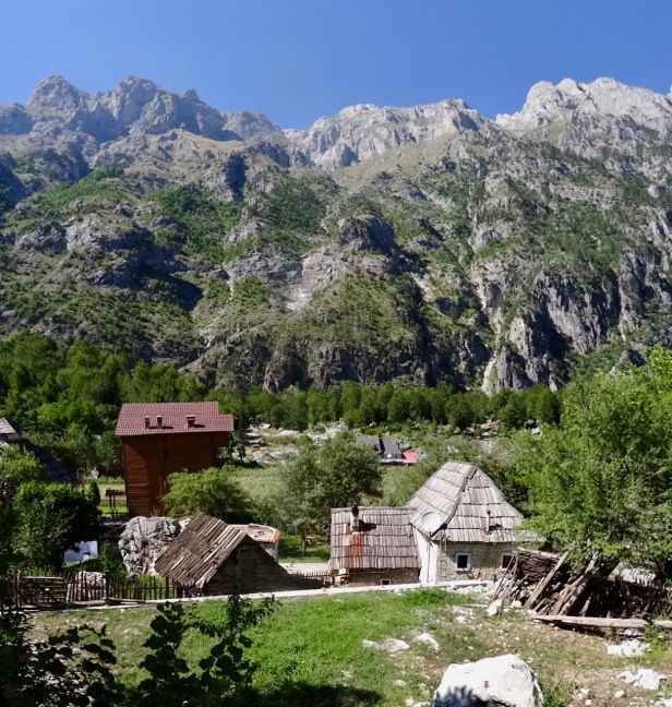
From Çerem we pushed on to Dobërdol, which is another 15km further and 700m up. About half way you pass through the tiny shepherd’s village of Balqin where another enthusiastic couple of kids invited us to their home for more coffee and bread.


By late afternoon we arrived in Dobërdol, a spread-out village set in beautiful open meadows with mountains all around. It appears that several entrepreneurial villagers have opened up accommodations recently, which has led to a lot of competition: long before you enter the village itself you will be met by children trying to convince you to stay in their place.

We chose to stay in the Leonardo hostel, which is the very first hostel as you enter the village. They offer meals and some simple private and dorm-style rooms, but since the views were magnificent, we chose to camp in their yard.
Day 2 (4 August 2017): Dobërdol to Milishevc
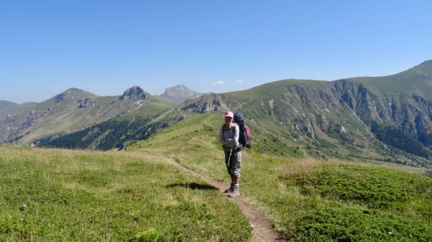
The second day we walked from Dobërdol to Milishevc. This section has magnificent views: almost the entire day is above tree line with fantastic views of the mountains in all directions.
Leaving Dobërdol, you immediately make a steepish ascent of 500m to gain the ridge North-North-West of town. The trail is faint and a bit tricky to find, so this is a section where GPS tracks come in handy.

Once you reach the top of the ridge, the next 8km are relatively flat. There are some confusing splits and signs on this section, so once again GPS tracks can help.
Technically, you enter Kosovo at this point, and by the end of the day you will enter Montenegro. But we encountered no border crossings checks at any point along the way.
At the end of the flat section, you start a descent of 700m down to the village of Roshkodol where you enter the woods again.
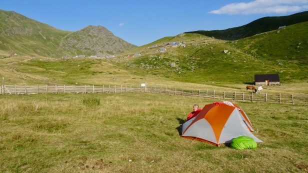
Another 6km further, you arrive at the tiny village of Milishevc. According to some descriptions there is a hotel there, but we couldn’t find it. We saw one house that could have been it, but it was closed. There is an open grass field in the middle of town with a nearby water spring that is the semi-official camping spot for tourists. We and another foreign couple setup our tents here. There is also no restaurant in town, but a friendly local farmer offered us some bread and cheese.


Day 3 (5 August 2017): Milishevc to Rekë e Allagas.
On day 3 we walked 16km from Milishevc to Rekë e Allagas, going through landscapes that are quite similar to what we saw on day 2.

In the first 2km you ascend 350m to Lumbardhi ridge with beautiful view.
The next 7km are a long and steep descent of 1200m, mostly through forests, until you finally arrive a Rugova Camp hotel complex next to a major road. It is hard on the knees and not the most interesting part of the circuit. The fancy restaurant and rooms are quite a contrast with the simple villages that you just passed through. We stopped here for an elaborate lunch: fresh trout from the local pond.
Once our bellies were filled, we had the face a 400m ascent to finish the remaining 7km to Rekë e Allagas.
Once you get there, hotel Panorama is heavily advertised, but we preferred hostel Ariu which is run by the very friendly Mr. Moustafa and his family. They have rooms there, but since they had a large tour group staying, we preferred to put up our tent in the large grass field in front of the hotel.
The dinner that we had at hostel Ariu was incredible. Not only was it absolutely delicious, but it was also huge – enough to feed a small army.

Day 4 (6 August 2017): Rekë e Allagas to Liqenat.
The official route for today takes you through the villages of Drelaj, Dugaivë and Kucishte to the final destination of Liqenat i Kuçishtes. This is a total distance of about 20km with lots of ups and downs.
This is one of those days where you want to deviate from the official route. My wife had actually foreseen this and warned me about it, but I was too stubborn to listen to her… Oops…
First, once you get to the village of Drelaj, you should take the time to climb to the peak of mount Hajla, which is the highest mountain in this region. I was afraid to run out of time, so we skipped it. Online descriptions say it is a relatively easy ascent, but we had some minor troubles route finding in this section, so a good map and/or GPS tracks might come in handy.
Second, there is a lot of very boring walking on tarmac roads between Drelaj, Kuçiste, and Liqenat. We walked from Drelaj to Kuçiste over a tarmac road, decided that we did not like this section, and asked a little restaurant along the road to call a taxi for us, which drove us to Liqenat. In retrospect, we should have arranged a taxi from Drelaj to Liqenat in advance (as suggested by the folks from Uncornered Market – see resources at the end). If you do that, you should have plenty of time to climb mount Hajla.
Once we got to Liqenat, we stayed at Villa and Restaurant Guri i Kuq, which is a large tourist complex with hotel rooms, bungalows, and a popular restaurant. It is close to the road and quite busy. But, hey, it’s a chance to take a shower and load up on comfort food and knock back some beers.
Day 5 (7 August 2017): Liqenat to Babino Polje.
On day 5 we hiked from Liqenat (Kosovo) to Babino Polje (Montenegro), a total distance of 16km with 1150m up (to the Jelenakpass) and then 1100m down.
Thankfully, we soon left the tarmac roads behind us and entered back into nature. The landscape on this section was very similar to what we saw on day 2: long gentle ridges, high above the tree line, with splendid views in all directions. This is not surprising, since the trail actually looped back and we were actually quite close to where were on day 2.


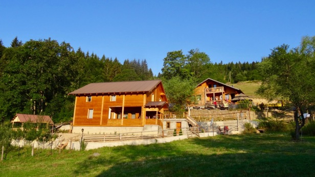
Once we got to Babino Polje, we stayed in hostel Triangle Woodhouse (which is also known as Armend Alija’s house). This hostel was quite a surprise. Even though it is in the middle of nowhere, it is run very professionally and they serve an absolutely gourmet dinner with very fancy drinks. It has only two (or maybe three) rooms, so you might want to call ahead.

Day 6 (8 August 2017): Babino Polje to Grebaje.
From Banino Polje we continued for 20km to the biggest town on the trek: Plav. As we left Banino Polje following the dirt road, we exited the forest for beautiful views of the cloud-filled valleys below.

As we continued up, we passed several lakes. Our expectations were high, as several locals that we met earlier on the trek had declared these to be the most beautiful lakes in the Balkans. However, we couldn’t help to be disgusted by the incredible amount of trash along the shores of these what would otherwise indeed have been beautiful lakes. Surely the local park service could have done a better job cleaning up and policing the visitors.


We arrived in Plav in the early afternoon. Plav is a very nice little city with some restaurants, bars, and culture. After the mandatory registration at the police station (where you have to show your cross-border permit) we rested our weary legs and had a couple of beers at one of the cafés on the main street.

Here we deviated from the official route to make a side trip to Prokletije National Park, which is the most rugged part of the Accursed Range. The waiter called a taxi for us, but when it failed to show up, a local having a coffee at the café offered to take us for the same rate. He drove us to Grebaje, the only place to stay in the national park.
Once in Grebaje, we got a rather uninspiring room in Eko Katun hotel (everything else was fully booked). At least the service was friendly and the restaurant was good. We could have camped for cheaper, but the camp sites are just as uninspiring as the room.
Day 7 (9 August 2017): Day hike to Tilijanka mountain.
We spent the next two days making day hikes in the national park. The park is essentially a deep valley flanked on both sides by amazing high jagged mountains.
The first day we did a long loop hike to the peak of Tilijanka mountain. We went up to the peak and came back the same way; you can also continue down the backside of the mountain and come back through the valley but that involves a steep descent over loose gravel. There are tons of trails in this area, and you can’t go wrong. Where ever you go, it’s a feast for the eyes. I will let the photos speak for themselves.


Day 8 (10 August 2017): Day hike to “kissing cats” window.
On our second day in Prokletije National Park we made a more ambitious day hike up Karanfil mountain and through the “famous” kissing cat window. This is hole in the mountain, covered by an arch which (with a good dose of fantasy) resembles a pair of kissing cats. It is long very steep hike up, but your effort is rewarded with an amazingly austere landscape full of protruding rocks. Once you get to the actual window, there is a short scramble up some vertical chains that requires tolerance to some minor exposure.


After finishing our day hike, we hitch-hiked back to Plav, where we spent some time sight-seeing, had a nice lake-front dinner at camping LakeViews, and spent the night at the basic bed and breakfast Ottoman Kula Redzepagic which is located in a historic mansion.


Day 9 (11 August 2017): Grebaje to Vusanje.
Day 9 started out innocently enough: once again we arranged for a taxi to skip the first kilometers of boring walking on a dirt road.
The are a couple of alternative routes on this section. We chose to follow the original route which involves a short but very steep climb up Mount Bora (don’t worry – it is still hiking and doesn’t rise to the level of a scramble). Once at the top of Mount Bora, the remainder of the day goes across a high plateau with amazing views, and eventually the trail switches back into a valley that takes you to Vusanje.
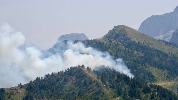
There was one major glitch, though. As we crossed the high plateau, we noticed several forest fires billowing smoke. Although the fires appeared to be minor, they were very near to the trail.
The wikiloc application on our phone showed an alternative trail, going in the opposite direction, that would avoid the fires and also take us to Vusanje. Indeed, for the first couple of hours, this alternative trail was splendid. We met some local women picking blueberries and bought a large bag of them.
However, about 5km before reaching Vusanje, the wikiloc trail suddenly ceased to exist. It was there on the app, but there was nothing on the ground. We decided to bushwack the remaining 5km, which turned out to be quite the adventure. The last part was extremely steep with very dense vegetation. We followed a dried-up creek bed and relied on the map and the contour lines in our phone GPS app to keep us going in the right direction towards Vusanje and to keep the gradient reasonable. Without the GPS it might not have ended well as there were large cliffs on this side of the mountain.
Several hours later, we ended up at the village of Vusanje, exhausted, muddy, and scratched up. But, as luck had it, we exited the forest literally at the doorstep of guesthouse Ulaj, run by a super sweet family, that had a private bedroom and a warm shower available. We dropped our packs, and recovered with some ice cold beers.


Day 10 (12 August 2017): Vusanje to Theth.
Day 10 was a relatively easy section of about 26km that takes you the town of Theth, back in Albania. This was my favorite day of the entire circuit. Most of the route takes you through exquisite mountain landscape that reminded me very much of the John Muir Trail in California. Once again, I will let the photos speak for themselves.


After you cross the Albania border (once again, no checkpoint of any kind), you pass through a field of abandoned bunkers dating back to the communist dictatorship.

Soon after the bunkers, you start a long descent down to the town of Theth. Just before you get there, you go down a steep series of switchbacks. When you get to the bottom of it and look back to where you just came from, it seems impossible (no worries, it looks much worse than it is, and there is actually no exposure whatsoever).

After the switch-backs, it still takes some time to get to Theth proper, which is actually quite a spread out town. As we started looking for a place to lay our head down, it quickly became clear that every single hotel was fully booked. After a very looking time of searching (and with help from booking.com on our phone) we finally snagged what must have been the very last available room at the lovely hotel Gjin Thana, which had just recently opened up.
Day 11 (13 August 2017): Theth to Valbone.
The section from Theth to Valbone is by far the most popular section of the whole circuit. Lots of travel agencies offer this section as a day hike, where they drop you off in Theth and pick you up in Valbone (or vice versa). In the previous 10 days we usually saw very few locals and almost no foreign tourists on any given day. On this section, we must have seen hundreds of other hikers.
Still, it is a nice enough section and I can see why people do it as a day hike. From Theth, you first hike up about 1000m over 7km to reach Valbona pass. This part is mostly through forests. About halfway up there is a cute little coffee café in the middle of nowhere, where pretty much everyone stops for a coffee and a pastry.

Once you cross the pass, the landscape opens up completely, and you hike down the other side, with amazing views of the Accursed Mountains and the Valbonë valley deep below.


When you get to the bottom of the valley, at the tiny village of Rragam, about 6km before Valbonë, you hit the road again. As we mentioned before, we hate walking over roads, so once again we paid one of the locals to drive us the last part.
We stayed in the same place where started on day one: in hotel Rilindja.
Day 12 (14 August): Revisit Çerem to Valbone.
We decided to add an extra day to revisit day 1, this time taking the high route instead of the low route.
Hotel Rilindja arranged a four wheel drive car to drive us to Çerem village. That way, we would end our hike back at the hotel, which simplified logistics. Also, it is easier to find the route in this direction and you hike mostly down instead of mostly up (there is still plenty of up, though).
It turned out that the high route was one of the highlights of the whole circuit, right up there with day 10. The landscape is extremely remote and rugged. You need a decent sense of direction and a good map or GPS, because the trails are rather faint. On the day we hiked it, there were low hanging clouds and fogs, which added an additional layer of mystery.


Additional Resources
The website http://www.peaksofthebalkans.com/ contains a wealth of information. Amongst other things it had a useful guide booklet that provides the hiking distances and altitude profiles for each stage of the trek.
As mentioned in the blog, Zbulo! travel agency helped us obtain the border crossing permits. They can also help with accommodation, transfers, guides, etc.
In November 2017 (some time after we completed the trek), Cicerone published a guide book on the Peaks of the Balkans. This will probably increase the popularity dramatically.
The Uncornered Market travel blog has a very detailed blog on the Peaks of the Balkans. If you want even more information, they also offer a “Peaks of the Balkans Beginner’s Guide” 52 page booklet (in the form of a downloadable PDF file) for sale for US$5.99.
Lonely Planet has an article on the Peaks of the Balkans.
The Balkan Natural Adventure website (in particular their resources page) publishes .gpx files that contain the GPS coordinates for almost all stages of the trek. I had some trouble using them: I had to manually edit the files to be able to download them into my Garmin GPS device, and I had to e-mail them to ask for one missing stage. If you want the complete and edited set of files, contact me (I don’t want to publish the edited files since they are not mine).
The same GPS files are also available on this German blog post of the Off The Beaten Track travel blog.
Finally, you can also find the GPS files on Wikiloc if you search for “Peaks of Balkans”.

Hey, thanks for this informative post. Can you share an approximate total cost? it seems like you spent considerably less than Uncornered Market
LikeLike
Hi James.
I think (but I could be mistaken) that the folks from uncornerned market hired a travel agency to make all arrangements and maybe also hired a guide. We made all the arrangements ourselves and we did not bring a guide. That is probably the biggest savings in cost, but you must be very comfortable with route finding and I highly recommend bringing a GPS track for the route because the trail is easy to lose in some places.
Our costs were:
(1) The only thing for which we used a travel agency (namely Zbulo!) was to arrange for our border crossing permits. That costs 45 euro per person, but it is very much worth it because it is difficult to arrange this by yourself.
(2) Flights to and from Tirana. There are several budget airlines that service Tirana. The cost obviously depends on where you are flying from.
(3) Transportation. Bus from Tirana to Schkoder: just a few euros. Bus and ferry combination ticket from Schkoder to Valbona: I don’t remember exactly anymore, but maybe 20 or 30 euro per person each way.
(4) Lodgings. We mostly stayed in small local guest houses, but also a few fancier hotels. The price was between 20 and 60 Euro per night for a double room (mostly on the lower end of that price range). We also brought a tent a camped a few times. The price for camping varies between free (0) and 5 euro per person.
(5) Food during the hike. If I remember correctly, a dinner costs around 10 euro per person.
LikeLike
Great post Bruno, extremely helpful for our planning efforts. Quick question for you. How much cash did you end up spending per trekking day and what currency did you bring with you?
LikeLike
Hi Brandon,
Have a look at the answer that I gave to James just a few hours ago. To summarize: after the fixed costs (flights, bus, ferry, cross border permit) the amount we spent per day varied a lot. On the cheapest day we camped for free and spent only 10 euro on food. On the most expensive day we spent maybe 100 euro (60 for a double room, 40 on food). Most days were somewhere in the middle. The amounts are totals for 2 people sharing a double room. In Montenegro and Kosovo the official currency is Euros. In Albania the official currency is Lek but Euros are also widely accepted. We carried mostly Euros and a little bit of Lek. ATMs are widely available in Tirana and Schkoder and (I think) Plav and Theth, but don’t count on them anywhere else on the trail.
— Bruno
LikeLike
Ah just seeing that. Very helpful.
LikeLike
Hi Bruno,
great post, going to hike this route end of this month.
I was wondering if you could send me the edited gps files? Also do you maybe have a gps file for the “high route (the third option)” from Valbone to Cerem?
Best,
Edo
LikeLike
Hi Edo, I already deleted the GPS files from my computer. But let me see if I can find them on my backup. It may take a couple of days.
LikeLike
Ok, thanks. Will wait 🙂
LikeLike
The GPS tracks can be downloaded here: https://github.com/brunorijsman/peaks-of-the-balkans-hike-gps-tracks/archive/1.0.zip
(If you are a techie, you can also access and contribute to the GPS tracks on GitHub here: https://github.com/brunorijsman/peaks-of-the-balkans-hike-gps-tracks)
The GPS tracks for the Valbone – Cerem section follow the boring low dirt road for the entire way (not even taking the short-cut).
I don’t have a GPS track for Valbone – Cerem the high route. We paid the hotel for a 4×4 jeep to drop us of at the start of the trail at the Cerem side. From there, the high-route trail to Valbone was reasonably well marked and reasonably easy to follow if you have some idea of which direction you are supposed to go (e.g. using off-line maps.me or off-line google.maps) and have some route finding skills. The trail is probably more difficult to follow in the reverse direction (Valbone to Cerem).
LikeLike
Thanks a lot Bruno!
Yes, we would like to do it from Valbona to Cerem. Hopefully we find it.
Best
Edo
LikeLike
Hello,
We are planning on doing a small part of the peaks of Balkan.
A 3 day hike were we start in Vusanje on day 1 and end in Teth. The second day we will hike from Teth to Valbona. The last day we will hike from Valbona to Vusanje.
We are with a group of 6 persons, some of them have no experience.
Are these hikes duable for them you think?
Kind regards,
bieke
LikeLike
Your proposed day 1 (Vusanje to Teth): This is my favorite section of the hike; the landscape is amazing and there are lots of bunkers near the border area. You will be crossing from Montenegro into Albania, so you need to arrange border crossing permits at least 2 weeks in advance (!). If I remember correctly, the trail on this section can be faint and is not very well marked, but you are essentially following a valley, so it is pretty obvious which way you need to go. Once you reach the saddle, the trail down to Teth becomes very clear and obvious. This day is about 26km with a decent amount of up and down, so it might be a bit of a challenge for those of you in the group that have never hiked before. Teth can get very busy in the high season, so it is worth making a reservation for accommodation (especially for 6 people).
Your proposed day 2 (Teth to Valbone): This is the most popular and most crowded (but still very scenic) part of the hike. The path is very clear and you should have no difficulty doing this section. There is little accommodation in Valbone and it is quite spread out, so once again a reservation would be recommended in the high season.
Your proposed day 3 (Valbone back to Vusanje): I have not done this section and I honestly have no idea of how difficult or easy it is. Looking at the map, it appears to go through roughly the same area that we went through following the high route from Cerem to Valbone. If so, this part might be quite remote, challenging and difficult to find the route. But again, I am just guessing since I never walked the direct route from Valbone to Vusanje. Note: Once again, you will be crossing the border so you need a border crossing permit.
You will need at least one experienced person in the group who is reasonably confident with route finding, since the trails are not always well marked. And everyone in the group will have to be comfortable walking 20+ km (5+ hrs) per day, with some reasonable amount of up and down. Once you are on the trail, you are committed, there is no option of bailing out half-way. That said: assuming you have some experienced people in the group, I think it will be a great experience for everyone. These 3 days are absolutely spectacular.
If you are unsure of your abilities, it might be worth hiring a guide. We never used a guide, but we heard good things about Zbulo travel agency.
LikeLike
Thank you so much for your answer!
We will prepare us as good as possible. Especially the tip for the route finding we will take with us.
Kind regards, Bieke
LikeLike
hi! Is it possible to receive a gpx file from you?
LikeLike
Sure, they are at https://github.com/brunorijsman/peaks-of-the-balkans-hike-gps-tracks
LikeLike
Dag Bruno, ik zou graag in contact komen i.v.m. het gebruik van een foto van je tocht Peaks of the Balkan. Met dank en groeten, Peter Daalder / NKBV / Hoogtelijn
LikeLike
Thank you for your information.
We will walk this route this week, but I have problems with the gpx files also. Can you help us out with your ones?
LikeLike
Enjoy the hike! Scroll up to the comments on July 7-9 for a link to the GPS tracks and related info.
LikeLike
Hi Bruno, I read all the comments so far but I wanted to check one more time to see if you happened to have found the gpx file for the Valbone – Cerem the high route. Also do you happen to have the gpx files for your two side hike days in the Prokletije National Park or any additional info for finding the trails. Thanks!
LikeLike
Hi Ryan. Sorry, no, I don’t have GPX files for the Valbone – Cerem high route or for Prokletije National Park. All the GPX files that I have are here: https://github.com/brunorijsman/peaks-of-the-balkans-hike-gps-tracks. Maps.me does a decent job of marking the trails in both places (make sure that you download both the Albania and Montenegro maps for offline use).
LikeLike
Dear Bruno,
Thank you for the post, extremely helpful! I’m going to PotB this August, and I have a couple of questions:
– do you think that it is feasible to do Valbona – Doberdol in one day, using the high route to Cerem?
– do you have by chance any info on the shortcut from Doberdol to Babino Polje? For time reasons I will need to cut off all the Kosovo section (albeit I read I won’t lose much)
Finally, did you have any problem in finding water?
Thank you!
LikeLike
Hi Roberto.
1) Yes, I do think that Valbona – Doberdol using the high route to Cerem is possible. The distance should not be a problem if you are a fit hiker. The main challenge is finding the high route. I am not sure about this specific area, but in the last couple of years my experience is that maps.me shows even the smallest trails very accurately (make sure you download the maps for off-line usage before you are out of cell phone reach).
2) No sorry, I don’t know anything about the shortcut. Once again, maps.me may help.
3) We had no trouble finding water, but wasn’t the cleanest water, so you might want to bring a filter or chemical purifiers.
PS: I wrote this blog quite a few years ago, and I think that by know the trail is much more well-known and well-developed (especially since the Cicerone guide came out).
LikeLike